Christopher S. Bond Bridge (Kansas City, Missouri)
Coordinates: 39 ° 7 ′ 22 " N , 94 ° 33 ′ 56" W.
| Christopher S. Bond Bridge | ||
|---|---|---|
| use |
|
|
| Crossing of | Missouri River | |
| place | North Kansas City and Kansas City , Missouri | |
| Entertained by | Missouri Department of Transportation | |
| construction | Cable-stayed bridge | |
| overall length | 523 m | |
| width | 42 m | |
| Longest span | 168 m | |
| Clear height | 16 m | |
| building-costs | $ 232 million | |
| start of building | 2008 | |
| opening | 2010 | |
| planner | Paseo Corridor Constructors | |
| location | ||
|
|
||
|
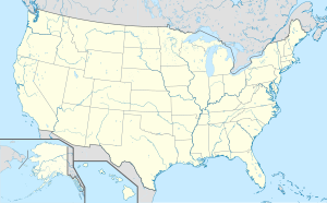
The Christopher S. Bond Bridge in the metropolitan area of Kansas City |
||
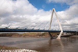
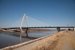
The Christopher S. Bond Bridge is a seven-lane road bridge over the Missouri River between North Kansas City and Kansas City , Missouri . It runs along Interstate 29 and 35 and US Highway 71 . The cable-stayed bridge was built in 2008–2010 to replace the four-lane Paseo Bridge from 1954 and is one of the busiest road bridges in the Kansas City metropolitan area with a daily traffic volume of over 100,000 vehicles . The operator is the Missouri Department of Transportation ; it is named after the former governor of Missouri Christopher Samuel Bond .
history

Development of the area north of Kansas City , Missouri , on the opposite side of the Missouri River , began in the late 19th century with the establishment of North Kansas City and the first plans for a road bridge over the river. In Kansas City, the Hannibal Bridge , the first railroad bridge ever built over the Missouri, was built in 1869 , but it wasn't until the opening of the ASB Bridge in 1911 that a road connection was established across the river. The ASB Bridge was built as a double-decker bridge for rail and road traffic and ran Missouri Route 9 on its upper level until 1987 . Another double-decker bridge in a similar configuration was built in 1917 with the successor to the Hannibal Bridge . This led to today's US Highway 169 on its upper level until 1956 , both bridges are still operated for rail freight traffic by the BNSF Railway .
In the 1950s, more road bridges were built over the Missouri in Kansas City, including the four-lane Paseo Bridge , which led US Highway 69 and 71 across the river since 1954 . With the expansion of the Interstate Highways , Interstate 29 and 35 also ran over the bridge and the associated increase in daily traffic from initially 6,800 vehicles to over 90,000 at the beginning of the 21st century made the Paseo Bridge increasingly a bottleneck. Interim closings of the bridge due to necessary repair work in 2003 and 2005 made the problem clear again and forecasts predicted a further increase in traffic to 110,000 vehicles per day by 2030; an expansion of the old suspension bridge was only possible to a limited extent.
| Missouri Bridge | Traffic route | ||||
|---|---|---|---|---|---|
| Railway bridge | Road bridge | ||||
| opening | closure | opening | closure | ADT (2016) | |
| I-435 Bridge (West) | - | - | 1987 | 30,300 | |
| I-635 Bridge | - | - | 1968 | 50,500 | |
| US 69 Missouri River Bridge | - | - | 2016 | 13,000 | |
| Hannibal Bridge (1869) | 1869 | 1917 | - | - | - |
| Hannibal Bridge (1917) ( BNSF ) | 1917 | 1917 | 1956 | - | |
| Buck O'Neil Bridge | - | - | 1956 | 34,600 | |
| ASB Bridge ( BNSF ) | 1911 | 1911 | 1987 | - | |
| Heart of America Bridge | - | - | 1987 | 26,000 | |
| Paseo Bridge | - | - | 1954 | 2010 | - |
| Christopher S. Bond Bridge | - | - | 2010 | 103,500 | |
| Chouteau Bridge | 1887 | 1951 | 1951 | 2001 | - |
| Chouteau Freeway Bridge | - | - | 2001 | 20,300 | |
| I-435 Bridge (East) | - | - | 1973 | 85,000 | |
| Harry S. Truman Bridge ( UP ) | 1945 | - | - | - | |

The Missouri Department of Transportation ultimately decided to build a new seven-lane road bridge downstream in the immediate vicinity of the old bridge, including the expansion of adjacent driveways and interchanges , which would handle a future traffic load of up to 130,000 vehicles. At the end of 2007, the contract for the kcICON infrastructure project worth USD 232 million went to Paseo Corridor Constructors , a joint venture consisting of Clarkson Construction , Massman Construction and Kiewit Construction . The final selection of the design drafts from Touchstone Architecture was made with the involvement of the cities and municipalities through the Community Advisory Group . Construction work on the pylon of the future cable-stayed bridge began in summer 2008 and the bridge, including the access roads, was opened to traffic six months before the planned end of the project in November 2010. The old Paseo Bridge was then closed and completely dismantled the following year.
description
The central element of the Christopher S. Bond Bridge is an asymmetrical one -hip cable-stayed bridge , the deck girder of which is attached to a pylon with 20 tensioning cables on each side. The 42 m wide deck girder made of solid wall girders with a 23 cm reinforced concrete deck forms spans of 167.6 m to the south bank (to Kansas City) and 137.5 m to the north bank (to North Kansas City). The seven lanes are 3.7 m wide, with four running north and three south; the central concrete protective wall is offset by about one meter from the central axis of the bridge. Several girder bridges totaling 217.5 m are connected to the main bridge up to the respective abutment , which adds up to the total length of the bridge to around 523 m. Eight steel pipes with a diameter of more than 3 m were used for the pile foundation of the 96 m high diamond-shaped A-pylon made of reinforced concrete. The 40 tensioning ropes are arranged in a fan system and carry the deck girder at a height of about 16 m above normal water level.
Web links
- Christopher S. Bond Bridge. John A. Weeks III.
literature
- Shreenath Rao, Paul Littleton, Jagannath Mallel: Missouri Demonstration Project: Design-Build Procurement Process for Construction on I-29/35 (kcICON) in Kansas City, MO. Final Report June 2013, Office of Infrastructure, Federal Highway Administration.
Individual evidence
- ^ To Architectural / Historic Survey of the City of North Kansas City, Missouri. Architectural and Art Historical Research, Kansas City, Missouri, February 1996, pp. 4-7.
- ↑ Thomas J. Gubbels: PASEO BRIDGE (Missouri River Bridge No. L07345). Historic American Engineering Record, HAER No. MO-116, Omaha, Nebraska 2008, pp. 24-31.
- ↑ Shreenath Rao, Paul Littleton, Jagannath Mallel: Missouri Demonstration Project: Design-Build Procurement Process for Construction on I-29/35 (kcICON) in Kansas City, MO. Final Report June 2013, Office of Infrastructure, Federal Highway Administration, pp. 9-15.
- ^ Kansas City District Traffic Volume and Commercial Vehicle Count Map. ( September 1, 2018 memento on the Internet Archive ) Missouri Department of Transportation, 2016.
- ↑ Christopher S. Bond Bridge, Kansas City, Missouri, USA. Touchstone Architecture. Retrieved August 5, 2018.
- ↑ Shreenath Rao, Paul Littleton, Jagannath Mallel: Missouri Demonstration Project: Design-Build Procurement Process for Construction on I-29/35 (kcICON) in Kansas City, MO. Final Report June 2013, Office of Infrastructure, Federal Highway Administration, pp. 15, 23, 46-48 and 52.
- ↑ Shreenath Rao, Paul Littleton, Jagannath Mallel: Missouri Demonstration Project: Design-Build Procurement Process for Construction on I-29/35 (kcICON) in Kansas City, MO. Final Report June 2013, Office of Infrastructure, Federal Highway Administration, p. 13.
- ^ John Gregerson: Cable-Stayed Bridge Built to Span a Century. ENR Midwest, November 28, 2011. Retrieved August 5, 2018.
- ↑ Christopher S. Bond Bridge. American Institute of Steel Construction. Retrieved August 5, 2018.
- ↑ Christopher S. Bond Bridge, Kansas City, Missouri. Massman Construction Co. Retrieved August 5, 2018.


