
City-Nord-Park


The City-North Park is a landmarked park in Hamburg . The character of the park is determined by the location between the office buildings of the eponymous City Nord .
location
The park forms the central green axis of the City Nord office building district in Hamburg's Winterhude district . It has an elongated north-south oriented roughly rectangular shape with an area of approx. 100,000 m². It represents a connection between City Nord and Hamburg's Stadtpark ; together with a network of ramps and bridges, it should also serve as a distributor for pedestrian traffic within the office block and separate it from the street level.
history
From the beginning of the planning, City Nord was planned as an "office city in the country", so the basic structure of the park was included in the first planning model from 1959 and later viewed as an essential part of all implementation plans . The planned main road, today's Überseering , was to be laid in an arch around the central green area.
As part of the specific planning of City Nord, three reports on the design of the green areas were submitted, of which the Hamburg building authorities selected that of the garden architect Günther Schulze for implementation. Schulze provided for suitable open spaces with a representative character to match the architecture of the surrounding office buildings and planned the park in conjunction with the design of the streets and footpaths. He renounced conifers and shrubs and chose plane trees and maples as the most important tree species. He arranged all park trees in groups with geometric boundaries. He also consistently did without fences and completely relied on clear pathways and connected meadow areas for the design. The area should only be delimited and divided by concrete walls that are no more than 60 cm high. Schulze wanted to supplement these elements with a large body of water with a waterfall on the facade of the most south-westerly office complex. All planned water areas were canceled in the 1970s due to the high costs. In a revision of the design, he then selected geometric bumps to further structure the terrain.
The desired water basin influenced the planning of the connecting paths between the park, office buildings and city park for over 10 years. Wide and open access roads and a generous connection to the city park were not planned. To date, the only practical way to cross from the city park is to use a pedestrian bridge. The park is separated from residential areas by the Überseering and the office buildings.
Up until the 1990s, maintenance of the park was kept to a minimum. The necessary pruning of trees was seldom done, the original rose beds were removed. As a result, the park increasingly lost its attractiveness for individual visitors. In the 2000s, there was initially an ideas competition for redesign, the results of which, however, were never implemented. Since 2009, care has been taken to preserve the original condition of the park. It is characterized by the responsible district office as "significant green planning of the sixties and seventies, in its main features of high quality design and worthy of garden art history".
Furnishing
The park has a large meadow in the southern area and a smaller one in the northern area, it is consistently provided with benches arranged in groups. A disc golf course with 14 lanes has been running through all parts of the park since 2012 .
Photographs and map
Coordinates: 53 ° 36 ′ 8 ″ N , 10 ° 1 ′ 18 ″ E


Southwest entrance on the Jahnring
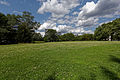
Main meadow

Middle part
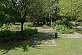
Seating groups in the northern part

Soil wall in the northern part


literature
- Sylvia Soggia: City-Nord - Europe's modern model city . Dölling and Galitz Verlag, Hamburg 2009, ISBN 978-3-937904-83-2 , p. 236-239 .
- Ralf Lange: Architecture in Hamburg . Junius Verlag , Hamburg 2008, ISBN 978-3-88506-586-9 , p. 189 .
Web links
- Description on hamburg.de .
- Description of the disc golf system
- Günther Schulze's curriculum vitae in the Hamburg Architecture Archive also contains a first draft in which the desired water basins are drawn.
- History of the park on the website of garden historian Joachim Schnitter
Individual evidence
- ↑ Length of the side measured in the satellite image using Google Maps.
- ↑ Sylvia Soggia: City-Nord - Europe Model City of Modernity . Dölling and Galitz Verlag, Hamburg 2009, ISBN 978-3-937904-83-2 , p. 238 .
- ↑ Quote in Sylvia Soggia: City-Nord - Europe's model city of modernity . Dölling and Galitz Verlag, Hamburg 2009, ISBN 978-3-937904-83-2 , p. 239 .

Outer Alster | City-Nord-Park | Eppendorfer Park | Friedrichsberger Park | Garden de l'Aigle | Willersweg green area | Green corridor Bebelallee | Green corridor Dulsberg | Langenfort green corridor | Meenkwiese green corridor | Hayns Park | Johannes-Prassek-Park | Langenhorn Youth Park | Kellinghusens Park | Schleidenpark | Sailor Park | City Park | Teetzpark | Juniper Park