Ciudad Madero
| Ciudad Madero | ||
|---|---|---|
|
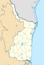
Coordinates: 22 ° 17 ′ N , 97 ° 50 ′ W Ciudad Madero on the map of Tamaulipas
|
||
| Basic data | ||
| Country | Mexico | |
| State | Tamaulipas | |
| Municipio | Ciudad Madero | |
| City foundation | 1807 | |
| Residents | 197,216 (2010) | |
| City insignia | ||
| Detailed data | ||
| height | 8 m | |
| Waters | Río Pánuco | |
| City Presidency | José Andrés Zorrilla Moreno | |
| Website | ||
Ciudad Madero is a city in the Mexican state of Tamaulipas . It has almost 200,000 inhabitants (as of 2010) and is located on the Río Pánuco . The city was created by a settlement in 1807 and was named in 1930 after Francisco Madero , a former president of Mexico.
Although it has various major, medium, and small industries, the oil industry (through the Petróleos Mexicanos ) is the most significant. Because the city is now the so-called oil capital of Mexico, and its refinery is one of the most modern in Latin America . As early as the 1970s, the port city of Ciudad Madero was annexed to the neighboring Tampico . The two cities now even share the common soccer club Tampico-Madero FC , whose stadium is halfway between the two towns.
In 1954 a technical college, the Instituto Tecnológico de Ciudad Madero , was founded.
sons and daughters of the town
- Pepe Jara (1928-2005), singer
- Antonio Salazar Castillo (* 1989), football player

