Ciudad Santa Catarina
| Ciudad Santa Catarina | ||
|---|---|---|
|
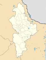
Coordinates: 25 ° 14 ′ N , 100 ° 27 ′ W Ciudad Santa Catarina on the map of Nuevo León
|
||
| Basic data | ||
| Country | Mexico | |
| State | Nuevo León | |
| Municipio | Santa Catarina | |
| Residents | 299,500 (2019) | |
| Detailed data | ||
| height | 690 m | |
| Time zone | UTC −6 | |
| Website | ||
Ciudad Santa Catarina is a city in the Mexican state of Nuevo León , which is part of the Zona Metropolitana de Monterrey . It is located in the southwestern part of the metropolitan area and is the capital of the Municipio Santa Catarina
geography
Santa Catarina is about 15 kilometers southwest of central Monterrey . City and town rank sixth by population within the state.
history
The name of this city comes from the Catholic Saint Catherine of Alexandria . The city of Santa Catarina was not "founded" in the traditional way. In the beginning it was just a resting place for travelers between Monterrey and Saltillo , which gradually developed into its own settlement. The first registered name was "Estancia de Santa Catarina".
During the French intervention in Mexico in the second half of the 19th century , President Benito Juárez spent a few days in Santa Catarina when he traveled to Monterrey. During this time Santa Catarina was raised to a village. The village category was retained until 1979 when the state government granted it city status.
Individual evidence
- ^ Cronología de Santa Catarina. Retrieved February 5, 2020 .

