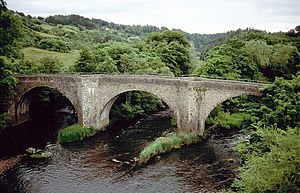
Clydesholm Bridge
Coordinates: 55 ° 40 ′ 32 " N , 3 ° 48 ′ 2" W.
| Clydesholm Bridge | ||
|---|---|---|
| The Clydesholm Bridge as seen from the modern bridge | ||
| use | Road bridge | |
| Subjugated | Clyde | |
| place | near Lanark | |
| construction | Arch bridge | |
| width | 4 m | |
| Number of openings | 3 | |
| Longest span | 18.3 m | |
| Arrow height | 15 m | |
| start of building | 1697 | |
| completion | 1699 | |
| planner | John Lockhart of Birkenhead | |
| location | ||
|
|
||
The Clydesholm Bridge is an arch bridge near the Scottish town of Lanark in the Council Area of South Lanarkshire . In 1971 the structure was included in the Scottish List of Monuments in the highest category A. Furthermore, together with a historical building on the north side, it forms a category B monument ensemble. A former additional classification as a Scheduled Monument was revoked in 1998.
history
As early as 1649, Burgh Lanark approached the Scottish Parliament with a motion to build a bridge. At that time there were ferry connections across the Clyde . There was also the possibility of using fords. Parliament approved that requests for donations for bridge building could be sent to all Scottish administrative units. Probably due to political uncertainties at the time of Cromwell , the construction was initially not pursued. The fundraising campaign was not started until 1694.
The Clydesholm Bridge was built between 1696 and 1699 to a design by John Lockhart of Birkenhead . It was part of the main route from Glasgow to Carlisle, which ran via Hamilton . This only changed with the completion of Thomas Telford's new route in the 1820s. With the construction of a new bridge about 50 m downstream, the Clydesholm Bridge became obsolete in 1956. The viaduct that once led the A72 over the Clyde is now only used as a pedestrian bridge.
description
The masonry viaduct spans the Clyde on the western edge of Lanark with three segment arches with spans of 18.3 m. The arrow height is around 15 meters. The masonry consists of quarry stone roughly hewn into ashlars , which is more accurately hewn along the parapets. Pointed icebreakers emerge from the pillars and extend over the parapets, where they form niches for pedestrians. The elevation of the four-meter-wide carriageway in the early 20th century required the parapets to be raised.
Individual evidence
- ↑ a b c d Listed Building - Entry . In: Historic Scotland .
- ↑ Entry on Clydesholm Bridge in Canmore, the database of Historic Environment Scotland (English)
Web links
- Entry on Clydesholm Bridge in Canmore, Historic Environment Scotland database

