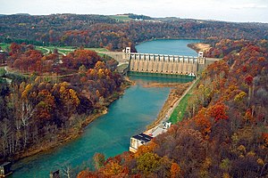
Conemaugh River Lake Dam
| Conemaugh River Lake | |||||
|---|---|---|---|---|---|
|
|||||
|
|
|||||
| Coordinates | 40 ° 25 '5 " N , 79 ° 21' 55" W | ||||
| Data on the structure | |||||
| Lock type: | Gravity dam | ||||
| Height above valley floor: | 41.8 m | ||||
| Building volume: | 272,000 m³ | ||||
| Crown length: | 365.6 m | ||||
| Base width: | 39 m | ||||
| Operator: | United States Army Corps of Engineers | ||||
| Data on the reservoir | |||||
| Water surface | 3.2 km² | ||||
| Reservoir length | 12.2 km | ||||
| Catchment area | 3 513 km² | ||||
The Conemaugh River Lake Dam is a dam on the Conemaugh River in Pennsylvania . Located on the border between Indiana and Westmoreland counties , it is primarily used for flood protection in areas downstream, including the city of Pittsburgh .
Barrier structure
The dam is located between the towns of Saltsburg and Blairsville , twelve kilometers above the confluence of the Conemaugh River and Loyalhanna Creek . It was completed in 1952 by the United States Army Corps of Engineers and is one of 16 comparable locks of the USACE in the Pittsburgh district. The building - a gravity dam of concrete - is 365.6 m long, up to 41.8 m m high and at the base 39 wide.
A small hydroelectric power station was built in 1989 to allow the dam to be used further . Its supply tunnel from the reservoir through the circular mountain "Bow Ridge" is the fourth tunnel at this point. Before that, a canal tunnel (1830) and two rail tunnels (1864 and 1907) were built directly below the current dam.
Reservoir
Since the Conemaugh Dam is primarily intended to regulate floods , the reservoir behind it called Conemaugh River Lake is relatively small despite a length of the reservoir of 12.2 kilometers. Its area is around 3.2 km² at normal water levels, but can multiply to 27.6 km² during floods.
In addition to its primary function, the reservoir is also used for recreation. A cycle path leads along the former railway line, which was built in 1907 and re-routed as a result of the construction of the dam, and crosses the lake four times over the historic stone arch bridges that are still preserved today.
Web links
- USACE: Conemaugh River Lake (English)
Individual evidence
- ↑ Tunnelview Historic Site ( Memento of the original from December 12, 2013 in the Internet Archive ) Info: The archive link was inserted automatically and has not yet been checked. Please check the original and archive link according to the instructions and then remove this notice. (PDF file; 627 kB)
- ^ Conemaugh Valley Conservancy: West Penn Trail

