
Copahue (volcano)
| Copahue | ||
|---|---|---|
 Southwest side of the Copahue with the lake Laguna Las Totoras in the foreground |
||
| height | 2997 m | |
| location |
Neuquén ( Argentina ), Bío-Bío ( Chile ) |
|
| Mountains | To the | |
| Coordinates | 37 ° 51 ′ 0 ″ S , 71 ° 10 ′ 0 ″ W | |
|
||
| Type | Stratovolcano | |
| Last eruption | 2012 | |

The Copahue is a volcano in the Andes Patagonia on the border between Chile and Argentina .
The 2997 meter high stratovolcano lies on the border between the Argentine province of Neuquén and the Chilean region of Bío-Bío . Nine volcanic craters are lined up along a two-kilometer rift zone with an ONO-WSW orientation. In the eastern summit crater there is a 300 meter wide acidic crater lake . During the eruptions in the 20th century, pyroclastic rock was hurled out of the crater lake.
The Copahue had at least six eruptions during the Holocene . The most recent eruption took place on December 22nd, 2012, the eruption column rose 1500 meters high. After increased activity of the volcano at the end of May 2013, around 3,000 residents were evacuated within a radius of 25 kilometers.
There are several hot springs around the volcano. In the nearby town of the same name in Copahue in Argentina , these are used for spa and healing purposes.
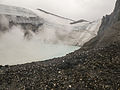
Copahue crater lake

Satellite image from December 22, 2012 with plume of smoke

.PNG)
Web links
- Copahue in the Global Volcanism Program of the Smithsonian Institution (English)
Individual evidence
- ↑ Copahue in the Global Volcanism Program of the Smithsonian Institution (English)
- ^ Chile and Argentina on alert over Copahue volcano eruption. In: BBC . December 23, 2012, accessed July 30, 2013 .
- ^ Chilean residents near Copahue volcano finally agree to leave. In: Euronews . May 30, 2013, accessed July 30, 2013 .