
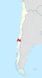
Región del Biobío
| Biobío Region VIII
Región del Biobío |
|||
|---|---|---|---|
  |
|||
| Symbols | |||
|
|||
| Basic data | |||
| Country | Chile | ||
| Capital | Concepción | ||
| surface | 23,890.2 km² | ||
| Residents | 1,557,414 (2017 census) | ||
| density | 65 inhabitants per km² | ||
| ISO 3166-2 | CL-BI | ||
| Website | gorebiobio.cl | ||
| politics | |||
| Intendant | Jorge Ulloa | ||
 |
|||


Coordinates: 36 ° 48 ′ S , 72 ° 53 ′ W
Biobío is the VIII. Region of Chile . The capital of the region is Concepción . Before the split of the XVI. Region Ñuble on September 6, 2018 a total of 2,037,414 inhabitants (as of 2017 census) on an area of 36,062 km².
The northern province of Ñuble, which was separated in 2018 and became an independent region and which includes the new capital Chillán and the important city of San Carlos , has around 480,600 inhabitants and an area of 13,178.5 km². The VIII. Region, which consists of the remaining three provinces, has only around 1,557,400 inhabitants on an area of 23,890.2 km² since September 2018.
geography
The Río Bío Bío is the most famous river. It used to be the border to the Mapuche area.
history
In 1550 the Spanish conquistador Pedro de Valdivia founded the city of Concepción at the mouth of the Río Bío Bío . The Spaniards expanded the city into a fortress to consolidate their power in the Mapuche area . The fortresses of Tucapel , Lebu , Angol , Purén and Arauco followed . In December 1553, the Mapuche attacked the Tucapel fortress and killed Pedro de Valdivia. In 1554 they also destroyed Concepción. One city after another was destroyed by them. The Spaniards rebuilt the cities, but continued attack. (see also: Arauco War )
In 1602, Governor Alonso de Ribera decided to see the Río Bío Bío as the border with the Mapuche area. In 1647 the Spaniards signed a peace treaty with them.
In 1660 Concepción was devastated by a severe earthquake. The Mapuche continued to attack Spanish fortresses. Only the Chilean and Argentine armies were able to decisively break their resistance in 1878. From now on, European immigrants can safely settle south of the Río Bío Bío .
On February 20, 1835 and May 22, 1960, the coast around Concepción was destroyed by large tsunamis and earthquakes.
Biobío was hit hard in the earthquake on February 27, 2010 .
Administrative division
The region is now divided into three (until the split of Ñuble in September 2018 four) provinces:
- Concepción , capital of Concepción
- Arauco , capital Lebu
- Bío-Bío , capital Los Ángeles
Other important cities are:
- Arauco
- Cañete
- Contulmo
- Coronel
- Curanilahue
- La Laja
- Lota
- Penco
- Quilleco
- San Pedro de la Paz
- Talcahuano
- Tomé
economy
Concepción is a large industrial region. Important branches of industry are the steel, coal and petro-industries, as well as fishing. Several large ports (e.g. Talcahuano ) and railway lines serve to supply central Chile. Biobío is Chile's largest wine- growing area (see also the article on viticulture in Chile ).
Tourism also plays a major role. The coasts with their wide beaches are very popular, especially the fishing villages such as Cobquecura, Coliumo, Caleta, Tumbes and Tirúa. In front of the coast there are several islands such as Isla Quiriquina , which is owned by the Chilean Navy, Isla Santa María, accessible from Punta Lavapié, and the impressive Isla Mocha, in the center of which there is a nature reserve with a few small lagoons is located. The horse cart is the most common mode of transport on the island.
The areas east of Chillán on the Argentine border are ideal ski areas, especially the Nevados de Chillán ski area. The Andes rise here to over 3000 m. Many mountains are volcanoes, such as B. the Antuco .
Nature reserves such as the Reserva Nonguén, only about 20 minutes by car from the city center of Concepción, the Parque Jorge Alessandri, between Concepción and Lota, but also national parks such as the Nahuelbuta, where the last araucarias of the coastal Andes are, but also the Laguna del Laja National Park are home to species such as the pudu dwarf deer, the condor and the puma.
The medium-sized Salto del Laja waterfall is a few minutes' drive from the Panamericana (or Ruta 5 Sur), between Chillán and Los Angeles.
The region along the Río Bío Bío offers excursion destinations with lagoons and forests and in the Itata Valley you can find several wine growers.
Web links
Individual evidence
- ↑ Chile: Regions and Agglomerations - Population Statistics, Maps, Graphics, Weather and Web Information. Retrieved April 14, 2018 .
- ↑ http://news.bbc.co.uk/2/hi/americas/8540289.stm
I. Región de Tarapacá | II. Región de Antofagasta | III. Atacama Region | IV. Región de Coquimbo | V. Región de Valparaíso | VI. Región del Libertador General Bernardo O'Higgins | VII. Región del Maule | VIII. Región del Biobío | IX. Región de la Araucanía | X. Región de los Lagos | XI. Región de Aysén del General Carlos Ibáñez del Campo | XII. Región de Magallanes y de la Antártica Chilena | XIV. Región de Los Ríos | XV. Región de Arica y Parinacota | XVI. Región de Ñuble | Metropolitan Region of Santiago