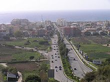
Costa da Caparica
| Costa da Caparica | ||||||
|---|---|---|---|---|---|---|
|
||||||
| Basic data | ||||||
| Region : | Lisboa | |||||
| Sub-region : | Lisbon metropolitan area | |||||
| District : | Setubal | |||||
| Concelho : | Almada | |||||
| Coordinates : | 38 ° 38 ′ N , 9 ° 14 ′ W | |||||
| Residents: | 13,418 (as of June 30, 2011) | |||||
| Surface: | 10.18 km² (as of January 1, 2010) | |||||
| Population density : | 1318 inhabitants per km² | |||||
| Postal code : | 2829 | |||||
| politics | ||||||
| Mayor : | António José Pinho Gaspar Neves | |||||
| Address of the municipal administration: | Junta de Freguesia de Costa da Caparica Avenida 1º Maio 9-B 2829-504 Costa da Caparica |
|||||
| Website: | www.costadacaparica.freguesias.pt | |||||
Costa da Caparica is a municipality and city in Portugal .
The community is 10.2 km² and has 13,418 inhabitants (as of June 30, 2011). The town received its town charter on December 9, 2004.
Costa da Caparica is located in Almada County , near the mouth of the Tagus into the Atlantic , on the opposite bank of Lisbon . From there the narrow-gauge railway “ Minicomboio da Caparica ” runs to Fonte da Telha, 9 km south .
Public facilities
Leisure and sports facilities
The football club Grupo Desportivo dos Pescadores da Costa de Caparica (GDPCC) plays on Campo Pescadores. Well-known former player of the team is Marco Airosa , who started his professional career here in 2004.
Web links
Commons : Costa da Caparica - Collection of images, videos and audio files
- Map of the Freguesia Costa da Caparica at the Instituto Geográfico do Exército
Individual evidence
- ↑ www.ine.pt - indicator resident population by place of residence and sex; Decennial in the database of the Instituto Nacional de Estatística
- ↑ Overview of code assignments from Freguesias on epp.eurostat.ec.europa.eu
- ↑ Survey on the city , Portuguese on ciberforma.pt, accessed on May 4, 2010
- ↑ https://www.national-football-teams.com/player/12411/-.html


