Cova Matinho (Cape Verde)
| Cova Matinho | ||
|---|---|---|
|
|
||
| Coordinates | 14 ° 55 ′ N , 24 ° 19 ′ W | |
| Basic data | ||
| Country | Cape Verde | |
| ISO 3166-2 | CV | |
| height | 500 m | |
|
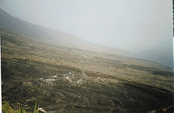
View from the Miradouro do Alto Espigão viewpoint on the eastern part of the village
|
||
Cova Matinho is a village in the east of the Cape Verde island of Fogo in the immediate vicinity of the active volcano Pico do Fogo .
Geography and history
Cova Matinho is located at an altitude of about 500 mdM on the eastern flank of the highest mountain in Cape Verde with 2829 m, the Pico do Fogo. It originated around 60 million years ago, with the island's current conical shape. The Pico de Fogo has several side craters and erupted several times in historical times. In the 1951 eruption there were no human lives to complain about, but the village of Bombardeiro on the east coast of Fogo was buried by the lava. Not far from there, a few kilometers inland, the village of Cova Matinho was founded, whose houses stand on the lava that was ejected in 1951. The lava served as building material in many cases. Today Cova Matinho is characterized by agriculture (mainly corn and beans) and cattle breeding (goats and some cows). In Fogo, the cultivation of the physic nut , from which machine oil was extracted, was an important economic factor - numerous overgrown bushes of this type still grow in the area around Cova Matinho.
Infrastructure
Cova Matinho is located on the well-developed ring road that goes around Fogo and connects all important places. This road connects São Jorge with the island's capital São Filipe , located in the southwest of Fogos, and with Mosteiros , the second largest town on the island, around 15 km away. The village can be reached several times a day (not on Sundays or public holidays) with the “ Aluguer ” buses typical of Cape Verde . However, they do not operate according to a fixed timetable, but depart as soon as enough passengers have arrived.
In Cova Matinho there is a school and shops for daily needs, but no accommodation for tourists.
Attractions
Not far south of the village, in which many houses are built from dark lava stone, the Miradouro do Alto Espigão viewpoint on the ring road offers an excellent view of the volcano and the eastern part of Fogo Island. One can clearly distinguish the relatively dark lava flows of 1951 from the lighter lava masses of previous eruptions (1769 and 1857).
A few kilometers north of Cova Matinho, one of the few beaches on the island, Praia Casa with black sand and bizarre rock formations made of basalt, extends on the east coast of Fogo .


