
Cross Gill
| Cross Gill | ||
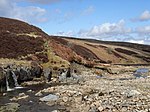
 The Cross Gill below the mouth of the Brown Gill |
||
| Data | ||
| location | Cumbria | |
| River system | Tyne (England) | |
| source | between Cross Fell and Round Hill 54 ° 42 ′ 47 ″ N , 2 ° 25 ′ 19 ″ W. |
|
| muzzle | in the South Tyne coordinates: 54 ° 45 ′ 42 " N , 2 ° 23 ′ 29" W 54 ° 45 ′ 42 " N , 2 ° 23 ′ 29" W.
|
|
| Left tributaries | Doubs Burn , Duffergill Burn | |
| Right tributaries |
Brown Gill , Redmire Burn , Reckergill Sike , Linkinhow Sike , Warm Burn |
|
The Cross Gill is a river in the north of the Pennines in Cumbria , England . The Cross Gill rises between the Cross Fell in the west and Round Hill in the east.
The Cross Gill flows through a narrow valley with steep slopes and has numerous short tributaries. The Doubs Burn , Brown Gill , Redmire Burn , Duffergill Burn , Reckergill Sike , Linkinhow Sike and Warm Burn, among other unnamed tributaries , flow into the Cross Gill.
It flows into the South Tyne between the settlements of Low Crossgill and Mid Crossgill .
The confluence of the Duffergill Burn (left) and Cross Gill

The Doubs Burn at its confluence with the Cross Gill

