Cumbres and Toltec Scenic Railroad
| Denver & Rio Grande Railroad San Juan Extension (Cumbres & Toltec Scenic Railroad) |
|
|---|---|
| National Register of Historic Places | |
| National Historic Landmark District | |
|
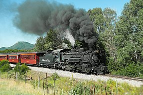
Cumbres and Toltec Scenic Railroad train |
|
| location | Columbus , Muscogee County , Georgia |
| Coordinates | 36 ° 59 '3.9 " N , 106 ° 18' 20" W |
| Built | from 1879 |
| architect | Denver & Rio Grande Railroad Baldwin Locomotive Works |
| NRHP number | 73000462 |
| Data | |
| The NRHP added | February 16, 1973 (extended April 24, 2007) |
| As NHLD declared | October 16, 2012 |
The Cumbres & Toltec Scenic Railroad since 1971, a narrow gauge - railway museum with 914.4 mm (= 3 feet ) track in the Rocky Mountains . It was part of a formerly large narrow-gauge railway network of the Denver and Rio Grande Western Railroad around Chama (New Mexico) . After the closure of the railway network, the section to Antonito (Colorado) with a length of 103 kilometers (64 miles) was saved from being dismantled by railway enthusiasts.
According to self-promotion, it is the highest narrow-gauge railway in the USA. Locomotives with tenders are used almost exclusively , but the museum railway also has diesel locomotives . Since 2012, the railway line has been named a National Historic Landmark of the USA under the name Denver & Rio Grande Railroad San Juan Extension .
National Historic Landmark
In 1971 the line was first used as a museum railway. In 1976, the railway line was added to the National Register of Historic Places (NRHP) as a Historic District (expanded in 2007); In 2012, the entire route and the structures that have been preserved or restored in their historic state were designated as the National Historic Landmark District (NHLD) in the states of Colorado and New Mexico .
Route
The route begins at the former junction in Chama, from where u. a. before a route Durango led.
It runs with steep slopes that often the prestressing require additional locomotives to Cumbres -Pass at 3053 meters altitude. With a stopover in Osier , it descends slightly on the Colorado plateau. The route meanders strongly and crosses the border of the states of New Mexico and Colorado 11 times after Osier until it finally reaches the end point Antonito.
The route crosses smaller rivers on 3 large steel bridges, has many smaller wooden bridges and two tunnels .
See also
literature
- Dan Pyzek: Cumbres and Toltec Scenic Railroad . National Register of Historic Places, Inventory, Nomination Form, Colorado & New Mexico State Railroad Authorities 1973 ( Online, PDF ).
- Keith E. Hayes, John P. Hankey: Denver & Rio Grande Railroad San Juan Extension . National Historic Landmark Nomination. Friends of the Cumbres & Toltec Scenic Railroad, Albuquerque. Edited by Robie Lange, National Park Service, National Historic Landmarks Program, Washington 2012 ( Online, PDF ).
Web links
- National Park Service: Denver & Rio Grande Railroad San Juan Extension (Cumbres & Toltec Scenic Railroad) (PDF) , Executive Summary; accessed November 28, 2017.
- Company website
- Friends of the Cumbres & Toltec Scenic Railroad (engl.)
Remarks
- ^ National Park Service: Denver & Rio Grande Railroad San Juan Extension (Cumbres & Toltec Scenic Railroad) (PDF) , Executive Summary; accessed November 28, 2017.
- ^ National Register of Historic Places: Digital Asset 73000462 , NRHP extension: Digital Asset 07000374 ; accessed November 28, 2017.
-
↑ Listing of National Historic Landmarks by State: Colorado. National Park Service , accessed July 20, 2019.
Listing of National Historic Landmarks by State: New Mexico. National Park Service , accessed July 20, 2019.
