Muscogee County
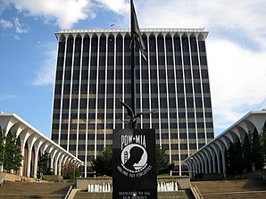
 Columbus Consolidated Government Center |
|
| administration | |
|---|---|
| US state : | Georgia |
| Administrative headquarters : | Columbus |
| Address of the administrative headquarters: |
Muscogee County Administration 100 10th Street Columbus, Georgia 31901 |
| Foundation : | June 9, 1825 |
| Area code : | 001 706 |
| Demographics | |
| Residents : | 200,000 (2014) |
| Population density : | 357.1 inhabitants / km 2 |
| geography | |
| Total area : | 572 km² |
| Water surface : | 12 km² |
| map | |
| Website : www.columbusga.org | |
The Muscogee County is a county in the state of Georgia to the United States . The county seat is Columbus and is identical to the extension of the county.
geography
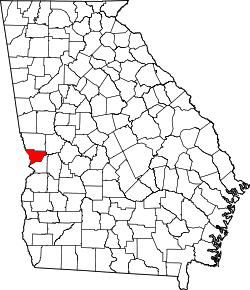
The county is located in western Georgia, on the border with Alabama and has an area of 572 square kilometers, of which twelve square kilometers are water, and is bordered clockwise by the following counties: Harris County , Talbot County and Chattahoochee Counties .
The county is part of the Columbus metropolitan area .
history
Muscogee County was formed on June 9, 1825 as the 69th county of Georgia from land acquired by the Creek Indians. It was named after the Muscogee Indians, from whom the Creek Indians and the Seminoles arose. Since 1971, the area of the county has corresponded to the urban area of Columbus - the first city-county council in the United States was established.
Demographic data
→ See also: Columbus: Demographic data
| growth of population | |||
|---|---|---|---|
| Census | Residents | ± in% | |
| 1840 | 3114 | - | |
| 1850 | 5942 | 90.8% | |
| 1860 | 9621 | 61.9% | |
| 1870 | 7401 | -23.1% | |
| 1880 | 10.123 | 36.8% | |
| 1890 | 17.303 | 70.9% | |
| 1900 | 17,614 | 1.8% | |
| 1910 | 20,554 | 16.7% | |
| 1920 | 31,125 | 51.4% | |
| 1930 | 43,131 | 38.6% | |
| 1940 | 53,280 | 23.5% | |
| 1950 | 79,611 | 49.4% | |
| 1960 | 116,779 | 46.7% | |
| 1970 | 155.028 | 32.8% | |
| 1980 | 169,441 | 9.3% | |
| 1990 | 178,681 | 5.5% | |
| 2000 | 186.291 | 4.3% | |
| 2010 | 189,885 | 1.9% | |
| Before 1900
1900–1990 2000 + 2010 |
|||
Web links
Individual evidence
- ↑ GNIS-ID: 357428. Retrieved on February 22, 2011 (English).
- ↑ Muscogee County at georgia.gov ( page no longer available , search in web archives ) Info: The link was automatically marked as defective. Please check the link according to the instructions and then remove this notice. . Retrieved February 14, 2011
- ↑ US Census Bureau - Census of Population and Housing . Retrieved March 15, 2011
- ↑ Extract from Census.gov . Retrieved February 14, 2011
- ↑ Excerpt from census.gov (2000 + 2010) ( Memento of the original from July 15, 2011 on WebCite ) Info: The archive link was inserted automatically and has not yet been checked. Please check the original and archive link according to the instructions and then remove this notice. Retrieved April 2, 2012
Coordinates: 32 ° 31 ′ N , 84 ° 52 ′ W


