Banks County
![Banks County Courthouse, listed on NRHP No. 80000969 [1]](https://upload.wikimedia.org/wikipedia/commons/thumb/1/15/Banks_County_Courthouse_%28Homer%2C_Georgia%29.jpg/298px-Banks_County_Courthouse_%28Homer%2C_Georgia%29.jpg) Banks County Courthouse, listed on NRHP No. 80000969 |
|
| administration | |
|---|---|
| US state : | Georgia |
| Administrative headquarters : | Homer |
| Address of the administrative headquarters: |
Banks County 144 Yonah Homer Road Homer, Georgia 30547 |
| Foundation : | December 11, 1858 |
| Made up from: |
Franklin County Habersham County |
| Area code : | 001 706 |
| Demographics | |
| Residents : | 18,395 (2010) |
| Population density : | 30.4 inhabitants / km 2 |
| geography | |
| Total area : | 606 km² |
| Water surface : | 1 km² |
| map | |
| Website : www.bankscountyga.org | |
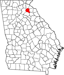
The Banks County is a county in the state of Georgia to the United States . The county seat is Homer .
geography
The county covers an area of 606 square kilometers, one square kilometer of which is water. It is bordered clockwise by the following counties: Stephens County , Franklin County , Madison County , Jackson County , Hall County, and Habersham Counties .
history
Banks County was formed from parts of Franklin County and Habersham County on December 11, 1858 , and named after Dr. Richard Banks . The land in which the county is located is part of the earliest Native American land cession in northern Georgia. The colonists settled here before the American Revolution. The first courthouse was built in 1863. After the civil war, the main sources of income were the cultivation of grain and cotton. In 1925 almost all cotton plantations were destroyed by a pest. What was not destroyed withered in the great drought that followed. After that, many farmers turned to beef and poultry production. After the construction of Interstate 85 , the population grew and now the second most important source of income is tourism.
Worth seeing
Fort Hollingsworth built in 1793, Banks County Historic Courthouse , The Ragsdale Gristmill built in 1860, the old county jail built in 1906 and the Blind Suzy Bridge . According to the Guinness Book of Records , Garrison Farm owns the largest egg in the world.
Demographic data
| growth of population | |||
|---|---|---|---|
| Census | Residents | ± in% | |
| 1860 | 4707 | - | |
| 1870 | 4973 | 5.7% | |
| 1880 | 7337 | 47.5% | |
| 1890 | 8562 | 16.7% | |
| 1900 | 10,545 | 23.2% | |
| 1910 | 11,244 | 6.6% | |
| 1920 | 11,814 | 5.1% | |
| 1930 | 9703 | -17.9% | |
| 1940 | 8733 | -10% | |
| 1950 | 6935 | -20.6% | |
| 1960 | 6497 | -6.3% | |
| 1970 | 6833 | 5.2% | |
| 1980 | 8702 | 27.4% | |
| 1990 | 10.308 | 18.5% | |
| 2000 | 14,422 | 39.9% | |
| 2010 | 18,395 | 27.5% | |
| Before 1900
1900–1990 2000 + 2010 |
|||
According to the 2010 census, the then 18,395 inhabitants were distributed over 6,700 inhabited households, which gives an average of 2.75 people per household. There are a total of 7595 households.
76.1% of the households were family households (consisting of married couples with or without offspring or one parent with offspring) with an average size of 3.14 persons. There were children under the age of 18 in 36.8% of all households and persons aged at least 65 in 25.6% of all households.
28.1% of the population were younger than 20 years, 23.1% were 20 to 39 years old, 28.8% were 40 to 59 years old, and 18.6% were at least 60 years old. The mean age was 38 years. 50.5% of the population were male and 49.5% were female.
91.7% of the population identified themselves as white, 2.3% as African-American , 0.3% as Native American and 0.9% as Asian Americans . 3.3% said they belonged to another ethnic group and 1.4% to several ethnic groups. 5.7% of the population was Hispanic or Latino .
The average annual income per household was 42,826 USD , while 16.3% of the population lived below the poverty line.
Places in Banks County
Banks County towns with 2010 census residents :
Cities :
- Baldwin - 3279 inhabitants
- Gillsville - 235 residents
- Lula - 2758 inhabitants
Towns :
- Alto - 1172 inhabitants
- Homer ( County Seat ) - 1141 residents
- Maysville - 1798 inhabitants
Web links
- Banks County at georgia.gov (engl.)
Individual evidence
- ^ Extract from the National Register of Historic Places . Retrieved March 13, 2011
- ↑ GNIS-ID: 349230. Retrieved on February 22, 2011 (English).
- ↑ US Census Bureau - Census of Population and Housing . Retrieved March 15, 2011
- ↑ Extract from Census.gov . Retrieved February 14, 2011
- ↑ Extract from census.gov (2000 + 2010). Accessed March 31, 2012
- ^ Profile of General Population and Housing Characteristics: 2010 . United States Census Bureau . Retrieved August 23, 2016.
Coordinates: 34 ° 21 ′ N , 83 ° 30 ′ W
