DeKalb County (Georgia)
![DeKalb County Courthouse in Decatur, listed in NRHP No. 71001016 [1]](https://upload.wikimedia.org/wikipedia/commons/thumb/1/11/Decatur%2C_GA_Courthouse.jpg/298px-Decatur%2C_GA_Courthouse.jpg) DeKalb County Courthouse in Decatur, listed on NRHP No. 71001016 |
|
| administration | |
|---|---|
| US state : | Georgia |
| Administrative headquarters : | Decatur |
| Address of the administrative headquarters: |
DeKalb County Administration 1300 Commerce Drive Decatur, GA 30030 |
| Foundation : | December 9, 1822 |
| Made up from: |
Henry County Gwinnett County Fayette County |
| Area code : | 001 404 |
| Demographics | |
| Residents : | 691,893 (2010) |
| Population density : | 995.5 inhabitants / km 2 |
| geography | |
| Total area : | 702 km² |
| Water surface : | 7 km² |
| map | |
| Website : www.co.dekalb.ga.us | |
The DeKalb County is a county in the state of Georgia to the United States . The county seat is Decatur .
geography
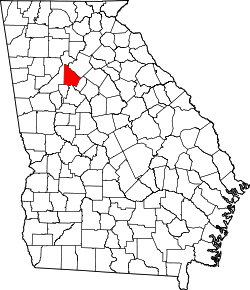
The county is located in central northwest Georgia and has an area of 702 square kilometers, of which seven square kilometers are water. It is bordered by counties in a clockwise direction: Gwinnett County , Rockdale County , Henry County , Clayton County, and Fulton County .
The county is part of the metropolitan area of Atlanta .
history
DeKalb County was formed on December 9, 1822 as the 56th County in Georgia from parts of Henry County, Gwinnett County and Fayette County. It was named after Baron Johann von Kalb , an army officer.
Demographic data
| growth of population | |||
|---|---|---|---|
| Census | Residents | ± in% | |
| 1830 | 10,042 | - | |
| 1840 | 10,467 | 4.2% | |
| 1850 | 14,328 | 36.9% | |
| 1860 | 7806 | -45.5% | |
| 1870 | 10,014 | 28.3% | |
| 1880 | 14,497 | 44.8% | |
| 1890 | 17,180 | 18.5% | |
| 1900 | 21,112 | 22.9% | |
| 1910 | 27,881 | 32.1% | |
| 1920 | 44.051 | 58% | |
| 1930 | 70.278 | 59.5% | |
| 1940 | 86,942 | 23.7% | |
| 1950 | 136,395 | 56.9% | |
| 1960 | 256,782 | 88.3% | |
| 1970 | 415,387 | 61.8% | |
| 1980 | 483.024 | 16.3% | |
| 1990 | 545.837 | 13% | |
| 2000 | 665.865 | 22% | |
| 2010 | 691,893 | 3.9% | |
| Before 1900
1900–1990 2000 + 2010 |
|||
According to the 2010 census, the 691,893 inhabitants at that time were distributed among 271,809 inhabited households, which gives an average of 2.50 people per household. There are a total of 304,968 households.
59.4% of the households were family households (consisting of married couples with or without offspring or one parent with offspring) with an average size of 3.18 persons. There were children under the age of 18 in 32.6% of all households and persons aged 65 and over in 17.4% of all households.
26.5% of the population were younger than 20 years old, 32.6% were 20 to 39 years old, 27.3% were 40 to 59 years old, and 13.8% were at least 60 years old. The mean age was 34 years. 47.9% of the population were male and 52.1% were female.
33.3% of the population identified themselves as white, 54.3% as African-American , 0.4% as Native American and 5.1% as Asian Americans . 4.5% said they belonged to another ethnic group and 2.4% to several ethnic groups. 9.8% of the population was made up of Hispanics or Latinos .
The average annual income per household was 50,799 USD , while 19.6% of the population lived below the poverty line.
Places in DeKalb County
DeKalb County localities with 2010 census population :
Cities :
- Atlanta - population 420,003
- Avondale Estates - 2,960 residents
- Brookhaven - 51,910 residents
- Chamblee - 9,892 inhabitants
- Clarkston - population 7,554
- Decatur ( County Seat ) - 19,335 residents
- Doraville - 8,330 inhabitants
- Dunwoody - population 46,267
- Lithonia - 1,924 inhabitants
- Pine Lake - 730 residents
- Stone Mountain - 5,802 residents
- Belvedere Park - 15,152 inhabitants
- Candler-McAfee - Population 23,025
- Druid Hills - 14,568 inhabitants
- Gresham Park - 7,432 residents
- North Decatur - 16,698 inhabitants
- North Druid Hills - 18,947 residents
- Panthersville - 9,749 residents
- Redan - 33,015 inhabitants
- Scottdale - residents 10,631
- Tucker - population 27,581
Web links
- DeKalb County at georgia.gov (English)
Individual evidence
- ^ Extract from the National Register of Historic Places . Retrieved March 13, 2011
- ↑ GNIS-ID: 1687424. Retrieved on February 22, 2011 (English).
- ↑ US Census Bureau - Census of Population and Housing . Retrieved March 15, 2011
- ↑ Extract from Census.gov . Retrieved February 14, 2011
- ↑ Excerpt from census.gov (2000 + 2010) ( Memento of the original from July 9, 2011 on WebCite ) Info: The archive link was inserted automatically and has not yet been checked. Please check the original and archive link according to the instructions and then remove this notice. Retrieved March 31, 2012
- ^ Profile of General Population and Housing Characteristics: 2010 . United States Census Bureau . Retrieved September 24, 2016.
Coordinates: 33 ° 46 ′ N , 84 ° 14 ′ W
