Hall County, Georgia
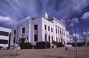
 Hall County Courthouse |
|
| administration | |
|---|---|
| US state : | Georgia |
| Administrative headquarters : | Gainesville |
| Address of the administrative headquarters: |
Hall County Administration 711 Green Street Gainesville, Georgia, 30501 |
| Foundation : | December 15, 1818 |
| Area code : | 001 770 |
| Demographics | |
| Residents : | 179,684 (2010) |
| Population density : | 176.2 inhabitants / km 2 |
| geography | |
| Total area : | 1112 km² |
| Water surface : | 92 km² |
| map | |
| Website : www.hallcounty.org | |
The Hall County is a county in the state of Georgia to the United States . The county seat is Gainesville , named after General Edmund P. Gaines .
geography
The county is in northern Georgia. It is located about 50 km to the northeast from South Carolina and about 60 km to the north from North Carolina . It covers an area of 1,112 square kilometers, of which 92 square kilometers are water surface, and is bordered clockwise by the following counties: Habersham County , Banks County , Jackson County , Barrow County , Gwinnett County , Forsyth County , Dawson County , Lumpkin County, and White County .
The county is known as Gainesville, GA Metropolitan Statistical Area by the Office of Management and Budget for statistical purposes .
history
Hall County was formed on December 15, 1818 as the 44th County of Georgia from Indian Land. It was named after Lyman Hall , one of three signatories to the Georgia Declaration of Independence and later Georgia Governor. The first power station was built in 1899, and Gainesville was the first southern American town to have electric street lights in 1899.
Part of the Olympic Games were held on Lake Lanier in 1996 .
Demographic data
| growth of population | |||
|---|---|---|---|
| Census | Residents | ± in% | |
| 1830 | 11,748 | - | |
| 1840 | 7875 | -33% | |
| 1850 | 8713 | 10.6% | |
| 1860 | 9366 | 7.5% | |
| 1870 | 9607 | 2.6% | |
| 1880 | 15,298 | 59.2% | |
| 1890 | 18,047 | 18% | |
| 1900 | 20,752 | 15% | |
| 1910 | 25,730 | 24% | |
| 1920 | 26,822 | 4.2% | |
| 1930 | 30,313 | 13% | |
| 1940 | 34,822 | 14.9% | |
| 1950 | 40.113 | 15.2% | |
| 1960 | 49,739 | 24% | |
| 1970 | 59,405 | 19.4% | |
| 1980 | 75,649 | 27.3% | |
| 1990 | 95,428 | 26.1% | |
| 2000 | 139,277 | 45.9% | |
| 2010 | 179,684 | 29% | |
| Before 1900
1900–1990 2000 + 2010 |
|||
According to the 2010 census, the then 179,684 inhabitants were distributed over 60,691 inhabited households, which gives an average of 2.91 people per household. There are a total of 68,825 households.
74.6% of households were family households (consisting of married couples with or without offspring or one parent with offspring) with an average size of 3.35 people. There were children under the age of 18 in 40.2% of all households and persons aged 65 or over in 23.6% of all households.
30.7% of the population were younger than 20 years, 27.1% were 20 to 39 years old, 26.1% were 40 to 59 years old, and 16.0% were at least 60 years old. The mean age was 35 years. 49.9% of the population were male and 50.1% were female.
74.1% of the population identified themselves as whites, 7.4% as African American , 0.5% as Indians and 1.8% as Asian Americans . 14.0% said they belonged to another ethnic group and 2.2% to several ethnic groups. 26.1% of the population was made up of Hispanics or Latinos .
The average annual income per household was 51,036 USD , while 18.8% of the population lived below the poverty line.
Places in Hall County

Hall County towns with 2010 census residents :
Cities :
- Buford - 12,225 inhabitants
- Gainesville ( County Seat ) - 33,804 residents
- Gillsville - 235 residents
- Lula - 2,758 inhabitants
- Oakwood - 3,970 residents
Towns :
- Braselton - 7,511 inhabitants
- Clermont - 875 inhabitants
- Flowery Branch - 5,679 residents
- Rest Haven - 62 inhabitants
Web links
- The Hall County in georgia.gov (Engl.)
Individual evidence
- ↑ GNIS-ID: 1686953. Retrieved on February 22, 2011 (English).
- ↑ Hall County at georgia.gov . Retrieved February 14, 2011
- ↑ CPH-T-5. Population Change for Metropolitan and Micropolitan Statistical Areas in the United States and Puerto Rico: 2000 to 2010. Retrieved February 21, 2018 .
- ↑ US Census Bureau - Census of Population and Housing . Retrieved March 15, 2011
- ↑ Extract from Census.gov . Retrieved February 14, 2011
- ↑ Excerpt from census.gov (2000 + 2010) ( Memento of the original from July 11, 2011 on WebCite ) Info: The archive link was inserted automatically and has not yet been checked. Please check the original and archive link according to the instructions and then remove this notice. Retrieved April 2, 2012
- ^ Profile of General Population and Housing Characteristics: 2010 . United States Census Bureau . Retrieved November 9, 2016.
- ^ Extract from the National Register of Historic Places . Retrieved March 13, 2011
Coordinates: 34 ° 19 ′ N , 83 ° 49 ′ W

