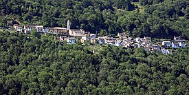
Cursolo-Orasso
| Cursolo-Orasso | |||
|---|---|---|---|
| Country | Italy | ||
| region | Piedmont | ||
| province | Verbano-Cusio-Ossola (VB) | ||
| local community | Valle Cannobina (Municipality) | ||
| Coordinates | 46 ° 6 ' N , 8 ° 34' E | ||
| height | 886 m slm | ||
| surface | 20.79 km² | ||
| Residents | 94 (November 30, 2018) | ||
| Population density | 5 inhabitants / km² | ||
| Telephone code | 0323 | CAP | 28827 |
Cursolo-Orasso is a former Italian commune in the province of Verbano-Cusio-Ossola (VB) in the Piedmont region . Since January 1, 2019, the two districts of Cursolo and Orasso belong to the newly formed municipality of Valle Cannobina . In 1928, Cursolo and Orasso were merged as a municipality.
geography
Cursolo and Orasso are in the upper Valle Cannobina . Their common area covers an area of more than 20 square kilometers and borders Switzerland in the north. Part of the territory, in particular the alpine pastures of Provola and Daila and the entire first section of the Gieöbach Cannobino to the source, belongs to the Val Grande National Park .
population
| Population development | |||||||||||||||
|---|---|---|---|---|---|---|---|---|---|---|---|---|---|---|---|
| year | 1861 | 1871 | 1881 | 1901 | 1921 | 1931 | 1951 | 1971 | 1991 | 2001 | 2011 | 2017 | |||
| Residents | 487 | 510 | 615 | 734 | 724 | 571 | 504 | 327 | 168 | 119 | 106 | 90 | |||
literature
- Various authors: Comuni della Provincia del Verbano-Cusio-Ossola. Consiglio Regionale del Piemonte, Chieri 2012, ISBN 9788896074503 .
- Various authors: Il Piemonte paese per paese. Bonechi Editore, Firenze 1996, ISBN 88-8029-156-4 .
Web links
Commons : Cursolo-Orasso - collection of images, videos and audio files
- Cursolo-Orasso (Italian) on tuttitalia.it
- Cursolo-Orasso (Italian) on comuni-italiani.it
- Cursolo-Orasso (Italian) on piemonte.indettaglio.it/ita/comuni

