
Cyril E. King Airport
| Cyril E King Airport | |
|---|---|

|
|
| Characteristics | |
| ICAO code | TIST |
| IATA code | STT |
| Coordinates | |
| Height above MSL | 7 m (23 ft ) |
| Basic data | |
| operator | Virgin Islands Port Authority |
| Start-and runway | |
| 10/28 | 2134 m × 46 m asphalt |

The Cyril E. King Airport is located on the island of Saint Thomas , US Virgin Islands , USA.
The airport operates with one runway that is relatively short at 2134 meters.
history
The airport was originally built for the United States Air Force in the 1930s and was in use until 1939. It was then a purely civil airport and was named in 1950 after the American President Harry S. Truman ; since 1984 it has been named after the former governor of the US Virgin Islands, Cyril E. King .
Destinations
There are mainly flight connections to destinations in the Caribbean and the US mainland .
Incidents
- On December 28, 1970, a jumped Boeing 727-2A7 the Trans Caribbean Airways ( air vehicle registration N8790R ) during landing twice up again, came from the runway , and caught fire. All 7 crew members and 46 of the 48 passengers survived, 2 passengers were burned in the wreckage of the aircraft.
- On April 27, 1976, a shot Boeing 727 to 95 of American Airlines (N1963) beyond the runway. This was preceded by a very late touchdown, the initiation of the go-around and then its termination again, all on a runway only 2134 meters long. 37 of the 88 occupants were killed (see also American Airlines flight 625 ) .

terminal 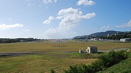
Runway
.jpg)
.JPG)
Web links
Commons : Cyril E. King Airport - Collection of images, videos and audio files
- Official website of the airport ( Memento of September 5, 2013 in the Internet Archive )
- Airnav.com access for STT / TIST
Individual evidence
- ↑ ibiblio.org
- ↑ seestjohn.com
- ↑ seestjohn.com
- ↑ accident report B 727-200 N8790R , Aviation Safety Network (English), accessed on February 3 of 2019.
- ↑ National Transportation Safety Board : "Aircraft Accident Report. File No. 1-0026" ( Memento of the original from December 12, 2014 in the Internet Archive ) Info: The archive link was automatically inserted and not yet checked. Please check the original and archive link according to the instructions and then remove this notice. , Washington, December 29, 1971.
- ↑ accident report B 727-100 N1963 , Aviation Safety Network (English), accessed on February 3 of 2019.