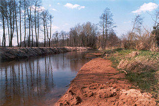
Czarna Staszowska
| Czarna Staszowska | ||
|
The regulated Czarna near Staszów |
||
| Data | ||
| location | Świętokrzyskie Voivodeship , Poland | |
| River system | Vistula | |
| Drain over | Vistula → Baltic Sea | |
| source | Kielcer Bergland (Heiligkreuzberge) | |
| muzzle | near Połaniec in the Vistula Coordinates: 50 ° 25 ′ 37 " N , 21 ° 19 ′ 34" E 50 ° 25 ′ 37 " N , 21 ° 19 ′ 34" E |
|
| Mouth height | approx. 154 m npm
|
|
| length | 61 km | |
| Catchment area | 1,358.6 km² | |
| Left tributaries | Wschodnia | |
| Right tributaries | Łukawka, Łagowica | |
| Small towns | Staszów , Połaniec | |
| Communities | Raków , Rytwiany | |
The Czarna Staszowska is a left tributary of the Vistula in Poland . It rises in Reżerwat Biale Lugi in the Świętokrzyskie Mountains ( Kielcer Bergland ), runs in a south-south-east direction through the district town of Staszów and flows into the Vistula at Połaniec after a run of 61 km, having shortly before included the Wschodnia . Its catchment area is given as 1358.6 km², the mean discharge at Polaniec with 5 m³ / s. Below Raków the Czarna flows through the dam of Chańcza.
Commons : Czarna Staszowska - collection of pictures, videos and audio files

