Dörstewitz
Dörstewitz is a part of the locality Knapendorf of the municipality of Schkopau .
geography
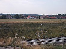
Dörstewitz is located southwest of Merseburg and west of the main town of Schkopau, directly between Delitz am Berge and Bündorf .
State road 172 and federal motorway 38 run west of Dörstewitz . To the north, the new Erfurt – Leipzig / Halle railway line with the Dörstewitz overtaking station passes the town.
history
According to local residents, Dörstewitz is said to have originally been located further east in the direction of Rattmannsdorf, but was then rebuilt at its current location due to the plague. The Krimitz desert, still listed as a desert in the Prussian General Staff Map from 1851, also a Slavic foundation like Dörstewitz, lies between Dörstewitz and Rattmannsdorf.
In 1270 Dörstewitz was bought by Bishop Friedrich von Togen. In 1697 Dörstewitz received a new church. Until 1815 the place belonged to the Hochstift-Merseburgischen Amt Merseburg , which had been under Electoral Saxon sovereignty since 1561 and belonged to the Secondogeniture Principality of Saxony-Merseburg between 1656/57 and 1738 .
In 1813, lignite deposits were discovered in both Knapendorf and Dörstewitz. The dismantling work began in 1830, but was stopped in 1928 due to water ingress. By the resolutions of the Vienna Congress Dörstewitz came in 1815 to Prussia and in 1816 the county Merseburg in the administrative district of Merseburg of the Province of Saxony assigned to which he belonged until 1,952th
On July 1, 1950, Dörstewitz was incorporated into Knapendorf. Knapendorf has been part of the municipality of Schkopau since 2005.
In the churchyard in Dörstewitz there is the common grave of the fallen from a neighboring flak battery with a memorial plaque.
Web links
Individual evidence
- ^ Karlheinz Blaschke , Uwe Ulrich Jäschke : Kursächsischer Ämteratlas , Leipzig 2009, ISBN 978-3-937386-14-0 , p. 84 f.
- ^ The district of Merseburg in the municipal directory 1900
Coordinates: 51 ° 24 ' N , 11 ° 55' E


