
Dürerweg
| Dürerweg | |
|---|---|
 Path marking of the Dürerweg, which represents the monogram of artist Albrecht Dürer |
|
| Data | |
| length | 39 km |
| location | South Tyrol , Trentino , Italy |
| Starting point |
Klösterle 46 ° 17 ′ 22.1 ″ N , 11 ° 20 ′ 3.8 ″ E |
| Target point |
Segonzano 46 ° 10 ′ 51.1 " N , 11 ° 15 ′ 50.8" E |
| Type | trail |
| Height difference | 2300 m |
| The highest point | 1208 m |
| Lowest point | 250 m |
| Months | March to November |
The Dürerweg is a hiking trail that leads from Klösterle in Sankt Florian near Neumarkt ( South Tyrol ) via Buchholz near Salurn to the earth pyramids of Segonzano in the Cembra Valley ( Trentino ). The road is named after the Nuremberg artist Albrecht Dürer named the 1494 during his first trip to Italy to Venice visited these places.
history
At the time of Albrecht Dürer's first trip to Italy, the valley floor of the South Tyrolean Unterland was evidently flooded by the Etsch, which regularly overflowed its banks, and thus blocked the way through the Salurner Klause . For this reason, the German artist had to take the alternative route to Buchholz and the Saúchsattel after his stay in the Klösterle, which was built in the 12th century and accommodated travelers and pilgrims . Albrecht Dürer documented some key points along the way as paintings.
route
The Dürerweg leads from Klösterle over the village of Laag and the south-west slopes of the Madruttberg to the Laukenbach gorge and on over the so-called Roman bridge to Buchholz . Here you pass a forge powered by a water mill, on various paths to the Saúch-Sattel (with sleeping facilities) and the bird-catching pasture, the Roccolo. Now it goes in the Cembra valley over the holy lake. The European long-distance hiking trail E5 leads to the village of Cembra with some farms and mansions. Now it goes over the castle of Segonzano to the earth pyramids.

Klösterle in the Adige Valley

St. Ursula in Buchholz
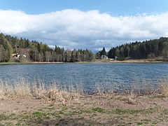
Lago Santo
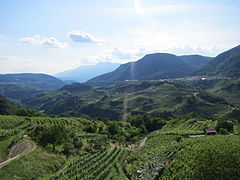
Cembra Valley at Cembra

Segonzano earth pyramids


