Dasidara
| Dasidara | ||
|
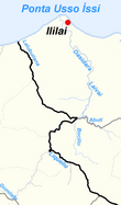
The Dasidara and its tributaries |
||
| Data | ||
| location | East Timor | |
| River system | Dasidara | |
| muzzle | in the Strait of Wetar Coordinates: 8 ° 24 '14 " S , 126 ° 43' 49" E 8 ° 24 '14 " S , 126 ° 43' 49" E
|
|
|
Aerial view |
||
The Dasidara is a river in the east of East Timor .
course
In the west of the Sucos Atelari the Gomilafo rises , which first flows to the southeast and then swings to the northeast and flows into the Suco Sagadate . The Liqueliu , which rises in the east of Atelari, flows to the northwest and forms the border between Sagadate and Wairoque , where the Gomilafo also flows into it. At the border between the Sucos Ililai and Wairoque the Bociliu and Abuti , which arise in Wairoque, flow . The river now called Laivai flows north and forms the border between the Sucos Ililai and Euquisi . Halfway to the sea, the river gets its final name Dasidara. Shortly before its confluence with the Wetar Strait on the Ponta Usso Íssi , the Dasidara leaves the border and crosses Ililai until the end of its course.
Web links
Individual evidence
- ^ Timor-Leste GIS-Portal ( Memento from June 30, 2007 in the Internet Archive )


