Dauin
| Municipality of Dauin | ||
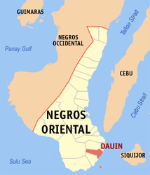
| Location of Dauin in the Negros Oriental province | ||
|---|---|---|

|
||
| Basic data | ||
| Region : | Central Visayas | |
| Province : | Negros Oriental | |
| Barangays : | 23 | |
| District: | 3. District of Negros Oriental | |
| PSGC : | 074609000 | |
| Income class : | 4. Income bracket | |
| Households : | 4464 May 1, 2000 census
|
|
| Population : | 27,786 August 1, 2015 census
|
|
| Coordinates : | 9 ° 11 ′ N , 123 ° 16 ′ E | |
| Postal code : | 6217 | |
| Mayor : | Rodrigo A. Alanano | |
| Geographical location in the Philippines | ||
|
|
||
Dauin is a Filipino municipality in the Negros Oriental Province . It has 27,786 inhabitants (August 1st 2015 census).
The municipality of Dauin borders on Bacong in the north and Zamboanguita in the south . In the west, a mountain range forms the border with Santa Catalina . Dauin is on the east coast of the island of Negros .
The municipality also includes the island of Apo , which is a popular place for scuba divers . Apo can be reached by boat from the mainland in around 30 minutes.
Barangays
Dauin is politically divided into 23 barangays .
|
|
