DeGoes Cliff
| DeGoes Cliff | ||
|---|---|---|
|
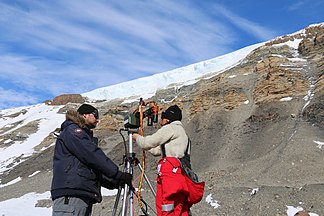
Scientists from GANOVEX XI working on DeGoes cliff in December 2015 |
||
| location | Victoria Land , East Antarctica | |
| part of | Usarp Mountains in the Transantarctic Mountains | |
|
|
||
| Coordinates | 71 ° 44 ′ S , 161 ° 54 ′ E | |
The DeGoes-cliff is a steep and 10 km long rock cliff in the East Antarctic Victoria Land . In the Morozumi Range of the Usarp Mountains , its northern end rises 10 km southwest of Mount Van Veen .
The United States Geological Survey mapped it using its own surveys and aerial photographs of the United States Navy from 1960 to 1963. The Advisory Committee on Antarctic Names named the cliff in 1970 after Louis DeGoes (1914-1997) of the National Academy of Sciences , executive director Secretary of the Polar Research Committee of the National Research Council .
Web links
- DeGoes Cliff in the Geographic Names Information System of the United States Geological Survey (English)
- DeGoes Cliff on geographic.org (English)
Individual evidence
- ^ Albert L. Washburn et al .: Memorial to Louis DeGoes. In: Geological Society of America Memorials , Vol. 29, December 1998 (accessed June 1, 2017).

