
Delftse Hout
| province |
|
| local community |
|
|
Area - land - water |
3 km 2 2.67 km 2 0.33 km 2 |
| Residents | 80 (Jan. 1, 2017) |
| Coordinates | 52 ° 1 ' N , 4 ° 23' E |
| Important traffic route |
|
| prefix | 015 |
| Postcodes | 2616 |
 |
|
Delftse Hout ( German Delft Forest ) is a local recreation area and at the same time a district in the northeast of the Dutch city of Delft .
history
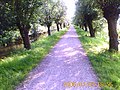
The recreational area was established in the 1970s. It consists mainly of young forest, green areas and a lake. The lake ( de Grote Plas , called the Great Pond ) was created when sand was extracted from the wasteland to build residential areas in the area in the 1960s . The beach consists of fine white sand; The extensive lake was divided into different areas, a paddling area for children, an area for dogs and a nudist beach. The area also has various nature observation points, a small game garden, a children's farm with a petting zoo , a water garden and a campsite.
In the south, the area borders partly on Heempark , but also on the furniture store Ikea, in the north and east it flows seamlessly to the Nootdorf recreation area Dobbeplas and in the west it is bordered by Europastraße 19 .

Delftse Hout in winter
Delftse Hout in summer

Delftse Hout in autumn

Beach on the Grote Plas

Water level marking: 3.70 meters below NAP !


Web links
- Website of the holiday park Delftse Hout (Dutch, German, English, French)
Individual evidence
- ↑ Kerncijfers wijken en buurten 2017 Centraal Bureau voor de Statistiek , accessed on May 26, 2018 (Dutch)
- ↑ Naaktstrandje Delftse Hout