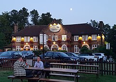
Denmark Hill
| Denmark Hill | ||
|---|---|---|
| Fox on the Hill Pub in Denmark Hill | ||
| Coordinates | 51 ° 28 ′ N , 0 ° 5 ′ W | |
| OS National Grid | TQ327760 | |
|
|
||
| administration | ||
| Post town | LONDON | |
| ZIP code section | SE5 | |
| prefix | 020 | |
| Part of the country | England | |
| London Borough | Southwark | |
| British Parliament | Dulwich and West Norwood | |
Denmark Hill is the name of a street and an area in the London borough of Camberwell in the borough of Southwark, east of Brixton and north of Herne Hill .
history
The namesake for Denmark Hill was probably Prince George of Denmark (1653–1708), the husband of Queen Anne of Great Britain (1665–1714), who liked to hunt in the then hardly built-up area. Much of the Denmark Hill and Herne Hill lands were purchased by wealthy timber merchant Samuel Sanders in 1783. Shortly afterwards he had a mansion built there for himself. More houses were added by the middle of the 19th century, which with the exception of three buildings have disappeared again. These are on the site of what is now King's College Hospital .
During the Second World War , at 113 Grove Park Street, there was an important radio eavesdropping point for British intelligence , called Denmark Hill Y Station . It was located within the then police station of the Metropolitan Police of Denmark Hill.
Infrastructure
Today, in addition to King's College Hospital, King's College London with the Cicely Saunders Institute , William Booth College , Maudsley Hospital , Denmark Hill train station and Ruskin Park are located in the area of Denmark Hill .
Personalities
- Samuel Prout (1783-1852), painter
- Sir Henry Bessemer (1813–1898), engineer and inventor
- Stan Tracey (1956-2013), musician
- Danny Kirwan (1950–2018), musician
- Jenny Agutter (* 1952), actress
- Rio Ferdinand (* 1978), football player
Web links
Individual evidence
- ^ Denmark Hill and Herne Hill in British History Online , accessed March 18, 2019.
- ^ Nigel West: Historical Dictionary of British Intelligence. Scarecrow Press, 2014, p. 254, ISBN 0-8108-7897-6 .


