Dent de Crolles
| Dent de Crolles | ||
|---|---|---|
|
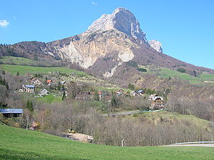
View from the south over Saint Pancrasse |
||
| height | 2062 m | |
| location | Department Isère , France | |
| Mountains | Chartreuse | |
| Coordinates | 45 ° 18 '28 " N , 5 ° 51' 20" E | |
|
|
||
| Normal way | from the Col du Coq ( 1434 m ) | |
The Dent de Crolles is a karst mountain ( 2062 m ) of the Chartreuse massif, 20 kilometers northeast of Grenoble (France) and was named after the nearby village of Crolles . The mountain is a hiking mountain and also visited by climbers and paragliders. Its striking southeast side rises steeply above the wide Grésivaudan valley , which connects Chambery with Grenoble. Access is usually from the Col du Coq , a narrow pass road with a top of 1434 m. Shortly below there is also a large parking lot for hikers. After the ascent to Col des Ayes over alpine meadows, the paths lead either north-east around the mountain to Trou de Glaz (see below) and over some rocky steps secured with ropes to Pas de Glaz (here the GR 9 hiking trail branches off through the Chartreuse). The path then leads to the summit on the karstified sloping plateau. The alternative path splits just above the Col des Ayes then goes east directly to the summit. This path is very steep and also has rock steps secured with ropes. Another alternative is the Sangle de la Barrère, a fairly airy stretch on a narrow ledge from the Pas de Glaz to the south, almost to the summit.
caves
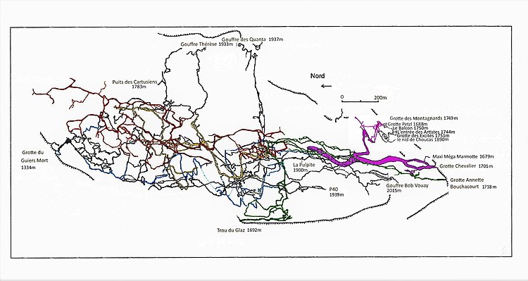
Inside the Dent de Crolles is one of the most complex and extensive cave systems in Europe. The cave is said to be a birthplace of modern speleology. The first more detailed explorations were carried out during the Second World War by Pierre Chevalier (1905-2001), Fernand Petzl (1912-2003), Charles Petit-Didier and others. The researchers soon found out that the Dent de Crolles had the deepest known cave in the world at 658 m. Today the cave system is the sixth deepest in France.
Since the climbing technique was not very advanced at that time , Pierre Chevalier and his colleagues had to invent and develop their own equipment. In the history of climbing, the first use of single rope technique , Prusik knots and mechanical ascenders is directly linked to exploring the Dent de Crolles caves. The use of Henri Brenot's “monkeys” (a climbing aid), nylon ropes (since 1942) and explosives (1947) is also worth mentioning. The book Pierre Chevaliers Escalades souterraines or Subterranean Climbers , also published in English, documents caving in the Dent de Crolles and is still considered a standard work on cave climbing because of its modest tone.
The cave system has been intensively studied since 1946. By 2007, nine separate entrances had been discovered and 58 kilometers of passageways had been explored. The two most important entry points are the “Trou du glaz” and “Guiers mort” caves.

literature
- Pierre Chevalier: Subterranean Climbers . National Speleological Society , 1975, ISBN 0-914264-15-X .
- Reinhard Scholl: Savoy. Rother hiking guide, Munich 2006, ISBN 3-7633-4321-0 .

