
Desecheo
| Desecheo | ||
|---|---|---|
 |
||
| Waters | Mona Passage , Caribbean Sea | |
| Geographical location | 18 ° 23 '3 " N , 67 ° 28' 52" W | |
|
||
| length | 1.7 km | |
| width | 1.3 km | |
| surface | 1.5 km² | |
| Highest elevation | Sego Can Ridge 218 m |
|
| Residents | uninhabited | |
| main place | Puerto de los Botes (historical) |
|
 |
||

Desecheo is a small uninhabited island northeast of the Mona Passage and part of the island group around Puerto Rico . It is 21 km from the west coast ( Punta Higüero ) of the main island of Puerto Rico and 50 km northeast of Mona . The island has an area of 1.5 km² (exactly: 1,524,613 m² or 376.74 acres ). This includes small and coastal side islands , including El Murro , a group of three steep rocks with heights between 30 and 44 meters in the west, and Islotes Dospiedras in the east. The best landing place for boats is Puerto de los Botes on the west coast, a natural harbor, but only to be used in good weather. During a settlement attempt in the 1920s, the area around Puerto de los Botes was cleared for agriculture. The West Valley above Puerto de los Botes and the larger Long Valley further east were used as pastures, and dams were built above the mouths of these valleys on the south coast to hold back the occasional flowing water for the cattle trough. Politically, the island is administered as part of the Barrio Sabanetas by the Mayagüez city council . It was discovered by Christopher Columbus during his second trip to the New World , but was not named until 1517 by the Spanish explorer Nuñez Alvarez de Aragón .
Desecheo's highest point is at 218 meters. The annual precipitation average is 1020 mm. The lack of surface water limits the flora to thorny bushes and shrubs, small trees and various cactus plants , including the critically endangered Harrisia portoricensis . The fauna consists of diverse species of marine birds , three endemic species of lizards ( Ameiva desechensis , Anolis desechensis and Sphaerodactylus levinsi ), introduced goats and rats, and a small population of rhesus monkeys that were introduced from Cayo Santiago in 1967 as part of an adaptation study . Before the introduction of the rhesus monkeys, the island was the largest nesting colony of the brown booby . No species currently nests on the island.
- Views
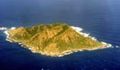
Desecheo seen from the southeast
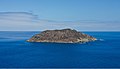
Oblique aerial view

Desecheo of Rincón seen from

Desecheo from Aguadilla seen from


Although Desecheo is politically part of Puerto Rico, geomorphologically it is not considered part of the Puerto Rican Bank along with the islands of Mona and Monito . It is believed that the island has been isolated since at least the Pliocene . In any case, the island is part of the Rio Culebrinas Formation, which suggests that it was once connected to Puerto Rico.
In August 2012, the US Fish and Wildlife Service reported the success of a rat extermination program on Desecheo Island. The originally non-native house rats had previously drastically reduced the fauna on the island and were v. a. also responsible for the fact that the seabird colonies that were still common at the beginning of the 20th century disappeared on Desecheo Island. After the rats have been exterminated, the seabirds are expected to return.
On an old French map from 1724, the island is referred to as Île de Zachée (Isle of Zacchaeus) ou Germaine .
literature
- Alexander Wetmore: The Birds of Desecheo Island, Porto Rico: The Auk, Vol. 35, No. 3 (July, 1918), pp. 333-340
- Victor M. Seiders, Reginald P. Briggs, Lynn Glover III: Geology of Isla Desecheo, Puerto Rico, With Notes on the Great Southern Puerto Rico Fault Zone and Quaternary Stillstands of the Sea. = Geological Survey Professional Paper 739, Washington DC 1972
- Albert J. Meier, Robert E. Noble and Herbert A. Raffaele: The Birds of Desecheo Island, Puerto Rico, Including a New Record for Puerto Rican Territory. Caribbean Journal of Science, Vol. 25, No. 1-2, 24-29, 1989
- Gary J. Breckon: Revision of the Flora of Desecheo Island, Puerto Rico, Caribbean Journal of Science, Vol. 36, No. 3-4, 177-209, 2000
- Manuel Valdés-Pizzini, Michelle Schärer-Umpierre, Carlos Carrero-Morales: Plan de Manejo, Reserva Marina Isla de Desecheo. San Juan, 2011
Web links
- US Fish & Wildlife Service: Desecheo National Wildlife Refuge, Puerto Rico (accessed October 18, 2018)
- Puerto Rican island to be cleared of rats to save rare wildlife (part, original link http://www.wildlifeextra.com/go/news/Desecheo-Island.html dead)
Individual evidence
- ^ University of Puerto Rico - Mayagüez Department of Biology Herbarium (MAPR): Desecheo Island Natural Reserve
- ^ Desecheo - Welcome to Puerto Rico.org . Found August 14, 2006.
- ↑ Harold Heatwole, Richard Levins and Michael D. Byer: Biogeography of the Puerto Rican Bank . In: Atoll Research Bulletin . 251, Jul. 1981, p. 11. Retrieved July 11, 2006.
- ^ Desecheo Island Natural Reserve . UPR-Mayagüez , Department of Biology Herbarium. Retrieved July 10, 2006.
- ↑ Puerto Rican island to be cleared of rats to save rare wildlife . Wildlife Extra News . Retrieved on August 27, 2012. (Part, original link http://www.wildlifeextra.com/go/news/Desecheo-Island.html dead)
- ↑ Isle de S. Domingue et débouquemens circonvoisins