Mayagüez
| Mayagüez | ||
|---|---|---|
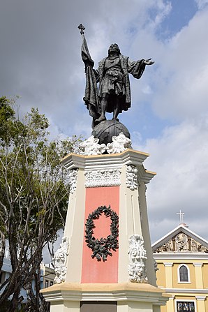
 Statue in the Plaza Colón |
||
 flag |
||
| Location in Puerto Rico | ||
|
|
||
| Basic data | ||
| Foundation : | September 18, 1760 | |
| State : | United States | |
| Outside area : | Puerto Rico | |
| Coordinates : | 18 ° 13 ′ N , 67 ° 9 ′ W | |
| Time zone : | Atlantic Standard Time ( UTC − 4 ) | |
| Residents : | 98,434 (as of: 2000) | |
| Population density : | 489.6 inhabitants per km 2 | |
| Area : | 709.89 km 2 (about 274 mi 2 ) of which 201.07 km 2 (about 78 mi 2 ) is land |
|
| Height : | 21 m | |
| Postcodes : | 00680, 00681, 00682 | |
| Area code : | +1 787 939 | |
| FIPS : | 72-52431 | |
| GNIS ID : | 1611495 | |
| Website : | mayaguezpr.gov | |
Mayagüez is a port city on the west coast of the west Indian island of Puerto Rico at the mouth of the Yagüez River . With 98,434 inhabitants, Mayagüez is the eighth largest city in Puerto Rico.
history
It was founded on September 18, 1760.
An earthquake on October 11, 1918 caused great damage to the city.
The consulates of Hungary and the Dominican Republic are located in Mayagüez . There is also a campus of Carlos Albizu University (Mayagüez University Center).
sons and daughters of the town
- Eugenio María de Hostos (1839–1903), writer and educator
- Rafael Quiñones Vidal (1892–1988), journalist and television presenter
- Vitín Avilés (1930-2004), singer
- Juan Mari Brás (1925-2010), Puerto Rican politician
- Roberto Roena (* 1938), salsa musician, percussionist, musical director of several orchestras and dancers
- Chucho Avellanet (born 1941), singer
- José Serrano (* 1943), American politician
- Néstor Torres (* 1957), jazz flutist
- Gina Lynn (* 1974), American porn actress
- JJ Barea (* 1984), Puerto Rican basketball player
- Frank Souffront († 1995), singer
Web links
Commons : Mayagüez - collection of images, videos and audio files
Individual evidence
- ↑ Recinto Mayagüez. In: albizu.edu . Retrieved January 9, 2020.
