Devoke Water
| Devoke Water | ||
|---|---|---|

|
||
|
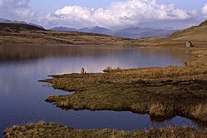
Devoke Water with a view of Scafell Pike (left), Esk Pike, Bowfell and Long Top |
||
| Geographical location | England , Cumbria | |
| Tributaries | five unnamed | |
| Drain | Linbeck Gill | |
| Islands | 1 | |
| Data | ||
| Coordinates | 54 ° 21 '40 " N , 3 ° 17' 59" W | |
|
|
||
| Altitude above sea level | 236 m ASL | |
| length | 1.2 km | |
| width | 400 m | |
| Maximum depth | 14 m | |
|
particularities |
Site of Special Scientific Interest |
|
Devoke Water is a lake in the Lake District , Cumbria , England .
The lake is at the western end of the Birker Fell . The lake has five unnamed tributaries on its south side. The Linbeck Gill is its outflow on the northwest side of the lake. There is a boathouse in the southeast of the lake.
The lake is part of the Brantrake Moss and Devoke Water Site of Special Scientific Interest . The Brantrake Moss is the largest bog in the mountains of west Cumbria. Devoke Water is the only nutrient-poor lake in western Cumbria and has a wealth of aquatic plants typical of these waters, some of which are rarely found elsewhere in the United Kingdom.
See also
Web links
Commons : Devoke Water - collection of images, videos and audio files
Individual evidence
- ↑ Brantrake Moss and Devoke Water on SSSI List for Natural England
