Diafarabé
| Diafarabé | ||
|---|---|---|
|
|
||
| Coordinates | 14 ° 8 ′ N , 5 ° 1 ′ W | |
| Basic data | ||
| Country | Mali | |
| Mopti | ||
| circle | Ténenkou | |
| ISO 3166-2 | ML-5 | |
| height | 277 m | |
| surface | 980 km² | |
| Residents | 14,907 (2009) | |
| density | 15.2 Ew. / km² | |
| politics | ||
| mayor | Lamine Djiré | |
|
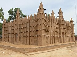
A clay mosque in Diafarabé
|
||
Diafarabé is the capital of a rural community of the same name in the administrative region of Mopti in Mali .
The municipality is located on the southern edge of the Ténenkou district . The rural community covers an area of around 980 square kilometers and extends over both sides of the Niger . The terrain lies in the Sahel zone . Topographically, Diafarabé is flat. The community consists of 10 villages and extends over an area of 980 km².
The local population is made up of the Fulbe , Bozo , Bambara and Marka . The local livelihoods come from cattle breeding, fishing and agriculture, as well as trade and craft. There is an opulent weekly market on Mondays.
Once a year the Fulbe celebrate their cultural festival Traversée des Animaux in Diafarabé . Its occasion is the annual cattle drive of large herds of cattle that swim across the river in the inland delta of the Niger . The festival is celebrated on a Saturday between November and December and is the largest of its kind. The tradition goes back to the year 1818 (age of the Massina Empire ). In 2008, UNESCO put the multi-day festival on the Representative List of the Intangible Cultural Heritage of Humanity .
On the eastern edge of Diafarabé-Bozo is a very well preserved mosque, the year of which is unknown (as of 1977). The entire facility covers an area of 277 m², 102 m² are allocated to an inner courtyard. The mihrab -Vorbau has a height of 4.5 m. the tower itself consists only of a shaft, which is designed as a regional architectural variant. Two other mosques are larger in Diafarabé-Peul from the 1920s (total area 412 m²) and in the country between Diafarabé-Bozo and -Peul (total area 700 m²), which was built in 1975.
Individual evidence
- ↑ 2009 census
- ↑ a b PLAN DE SECURITE ALIMENTAIRE COMMUNE RURALE DE DAIFARABE (2006-2010) / Commune rurale de Diafarabé ( page no longer available , search in web archives ) Info: The link was automatically marked as defective. Please check the link according to the instructions and then remove this notice.
- ↑ Mali cattle crossings
- ↑ Ross Velton: Mali: The Bradt Safari Guide , p. 89 in the Google book search
- ^ KT Wagenaar, A. Diallo, AR Sayers: Productivity of Transhumant Fulani Cattle in the Inner Niger Delta of Mali in the Google book search
- ↑ Cultural space of the Yaaral and Degal.
- ^ A b Dorothee Gruner, Die Lehmmoschee am Niger , p. 132 f. (see lit.)
literature
- Dorothee Gruner, The Lehmmoschee am Niger , documentation of a traditional building type, Franz Steiner Verlag Stuttgart, 1990, ISBN 3-515-05357-3


