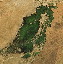
Mopti region
| Mopti | |
|---|---|
| Basic data | |
| Country | Mali |
| Capital | Mopti |
| surface | 88,752 km² |
| Residents | 2,037,330 (2009 census) |
| density | 23 inhabitants per km² |
| ISO 3166-2 | ML-5 |
Coordinates: 14 ° 35 ′ N , 3 ° 20 ′ W
The Mopti region is located in the center of Mali . It has an area of 79,017 km² and according to the last census in 2009 had about one million inhabitants. According to the census, the population for 2009 is 2,037,330.
The residents include Bozo , Dogon , Songhai , Fulbe, and Bambara .
The most important cities are the regional capital Mopti , Djenné and Douentza . In the Mopti region lying Bandiagara Escarpment and the Great Mosque of Djenne as a UNESCO World Heritage Site and well-known tourist destinations. The Niger River fans out here to form the inland delta. The Hombori Tondo is the highest point in Mali.
The region lies in the Sahel zone . It was an exporter of rice, fish and cattle until the 1970s. Due to the droughts in the 1970s and early 1980s (see famine in the Sahel zone ), Mopti suffers from considerable deficits in the production of staple foods, especially grain.
Circles: Bandiagara , Bankass , Djenné , Douentza , Koro , Mopti , Ténenkou , Youwarou
swell
- Hugo De Groote, Orou-Kobi Douro-Kpindou, Thomas Togo: Biological Control of Locusts and Grasshoppers in the Dogon Area: a Participatory Rural Appraisal . 1997
- Bevölkerungsstatistik.de
Individual evidence
- ↑ INSTAT: Results of the 2009 census (PDF; 935 kB)


