
Mopti
| Mopti | |||
|---|---|---|---|
|
|||
| Coordinates | 14 ° 30 ′ N , 4 ° 12 ′ W | ||
| Basic data | |||
| Country | Mali | ||
| Mopti | |||
| ISO 3166-2 | ML-5 | ||
| height | 268 m | ||
| Residents | 114,296 (2009) | ||
 The center of Mopti as seen from the Niger. In the background the indentation of the "harbor".
|
|||


Mopti is a town in Mali with 114,296 inhabitants and the administrative seat of the region of the same name . It is located about 650 kilometers from Bamako .
The regional capital Mopti is located at the confluence of the Bani and Niger , between Timbuktu and Ségou . The core of Mopti lies on three islands, which is why it was given the name “ Venice Malis”. The place was founded in the 19th century as a small Bozo settlement. In 1905 a colonial administration was established on site.
Individual districts are located on islands and are connected by dam structures. Charlotville is the oldest part of the city, known as the European Quarter in colonial times . The local population was relocated to the newly built Komoguel residential area at the beginning of the 20th century . For this reason, the great mosque of Mopti (Mosquée de Komoguel) was built there. It was built from 1933 to 1935 on the site of a mosque built in 1908 and restored from 2004 to 2006. Today's old town is a popular tourist destination with its markets and the Mopti mosque.
Mopti is the seat of the Mopti diocese .
population
In Mopti, the residents are ethnically heterogeneous. The settlement areas overlap, blurring the boundaries, melting pot effect. This is typical for Mopti, as it is a favored settlement area in its short history. A high percentage of them are Fulbe . There are also Marka , Bambara , Bozo , Bobo and, in splinter groups, Mossi .
Economy and Transport
Mopti is particularly characterized by trade and craft. The city is a trading center for fish, cattle and grain. Fish is exported as smoked and dried fish. Important branches of trade are weaving, iron and leather processing, pottery and boat building ( pinasses up to 50 tons).
In addition to the country's second largest commercial center, Mopti is the country's most important port. Ferries connect Mopti with Timbuktu , Gao , Koulikoro and Djenné . The Mopti Airport is located about 12 kilometers east of the city at Sévaré .
The situation in 2012
After a military coup in Bamako in March 2012, Azawad's declaration of independence by the Tuareg rebels on April 6, 2012 and the Islamist group Ansar Dine shortly afterwards came to power in northern Mali, chaos reigns supreme. A 20-minute Powerpoint presentation shows snapshots from Mali from Aug./Sept. 2012.
gallery
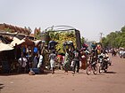
Market in Mopti

Water-based public transport at the port of Mopti

The port of Mopti

In the port of Mopti

Rock salt from Taoudenni in the port of Mopti

Rock salt in the Mopti market


Climate table
| Mopti | ||||||||||||||||||||||||||||||||||||||||||||||||
|---|---|---|---|---|---|---|---|---|---|---|---|---|---|---|---|---|---|---|---|---|---|---|---|---|---|---|---|---|---|---|---|---|---|---|---|---|---|---|---|---|---|---|---|---|---|---|---|---|
| Climate diagram | ||||||||||||||||||||||||||||||||||||||||||||||||
| ||||||||||||||||||||||||||||||||||||||||||||||||
|
Average monthly temperatures and rainfall for Mopti
Source: wetterkontor.de
|
|||||||||||||||||||||||||||||||||||||||||||||||||||||||||||||||||||||||||||||||||||||||||||||||||||||||||||||||||||||||||||||||||||||||||||||||||||||||||||||||||||||
Town twinning
Sister cities of Mopti are
- Chartres-de-Bretagne (France)
- Mortagne-au-Perche (France)
- Bouaké , Ivory Coast
Personalities
Amadou Toumani Touré (* 1948 in Mopti) was the President of Mali from May 2002 to March 2012.
See also
literature
- Dorothee Gruner, The Lehmmoschee am Niger, documentation of a traditional building type, Franz Steiner Verlag Stuttgart, 1990, ISBN 3-515-05357-3
Web links
Individual evidence
- ↑ INSTAT: Results of the 2009 census (PDF; 957 kB)
- ↑ a b c Dorothee Gruner, Die Lehmmoschee am Niger , p. 200 (see lit.)
- ↑ a b Dorothee Gruner, Die Lehmmoschee am Niger , p. 127 (see lit.)
- ↑ Snapshots from Mali, Aug./Sept. 2012 (20-minute PowerPoint presentation, English)
- ↑ site Chrartres-de-Bretagne - Les villes jumelées
- ↑ Montagnes-au-Perche website
- ↑ Website Bouaké - Villes amies ( Memento of the original from October 20, 2014 in the Internet Archive ) Info: The archive link was inserted automatically and has not yet been checked. Please check the original and archive link according to the instructions and then remove this notice.