Bandiagara Rocks
| Bandiagara Rocks (Dogon Land) | |
|---|---|
|
UNESCO world heritage |
|

|
|
| The Bandiagara rock massif |
|
| National territory: |
|
| Type: | mixed |
| Criteria : | v, vii |
| Surface: | 327,390 ha |
| Reference No .: | 516 |
| UNESCO region : | Africa |
| History of enrollment | |
| Enrollment: | 1989 (session 13) |
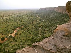
The Bandiagara rock massif ( French Falaise de Bandiagara ) is located in the Dogon country in southern Mali . The rock massif begins 100 kilometers east of the regional capital Mopti and ends 44 kilometers northeast of the city of Bandiagara on the Grandamia massif. It has a length of 200 km.
Geology and geography
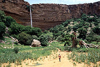
The rocks of the massif reach a height of 500 m above the lower sandy plains of the south. The eastern edges of the plateau are marked by steeply sloping layers. The Seno Gondo plain connects to the east . As a solid, ferrous and therefore red sandstone massif, the plateau in the northeast with the witness mountain Hombori Tondo , also the highest mountain in Mali, reaches a height of 1115 meters above sea level. To the west, the Paleozoic sandstone layers submerge under the much younger alluvial soil of the Niger Basin ( Niger Inland Delta). This rock massif plays a major role as a place of refuge and residence for the Dogon people, who number around 300,000.
Residents
The cave-dwelling tribe of the Tellem , who were later expelled by the Dogon ethnic group, lived in the narrow valleys of the mountain range from at least the 10th century. Dozens of villages lie at the foot of the sandstone massif , including Kani Bonzon . The Dogon migrated into the area from this direction and spread over the rest of the plateau, the hill and the steppe of the Seno-Gondo during the 14th century . The places of worship erected by the Tellem were not destroyed by the Dogon, but integrated into their own traditions over time.
A whole series of cemeteries are embedded in the rock face, which can only be reached with ladders. Typical of the villages is the low- rise meeting place ( toguna ) with its brushwood roof. Allegedly, the low ceiling is supposed to ensure that excited participants in a palaver who jump up during the discussion bump their heads and are thus brought to reason. More likely it is the explanation that the roof is also used as a general place to stay.
Above the cliff lies the Sangha community , consisting of 13 villages , which is considered the cultural center of the Dogon with its numerous religious sites. With the increasing spread of Islam in the 19th century, mosques and animistic shrines were built in some villages right next to the Toguna.
UNESCO world heritage
The rocks of Bandiagara and around 250 surrounding villages were placed on the UNESCO list of world cultural and natural heritage in 1989 . To justify the entry in both groups of the list, reference was made to the role that natural conditions play in the traditions and life of the Dogon.
| UNESCO ID | Official name | region | Coordinates | Area in hectares | comment | image |
|---|---|---|---|---|---|---|
| ML-516 | "Rocks of Bandiagara (Land of the Dogon )" (1989) | |||||
| 516-001 | Bandiagara Rocks | Mopti | 14 ° 10 ′ 0 ″ N , 3 ° 55 ′ 0 ″ W. | 326 950.00 | Settlement area of the Dogon |

|
| 516-002 | Songo village | Mopti | 14 ° 24 ′ 21 ″ N , 3 ° 42 ′ 0 ″ W. | 440.00 | known for rock carvings and the Dogon circumcision rite that takes place every three years |

|
gallery
literature
- Thomas Krings, Sahel countries, WBG country customers, 2006, ISBN 3-534-11860-X
Web links
Individual evidence
- ↑ Mamadi Dembele: The Land of the Dogon . In: Wolfgang Lauber (Ed.): Architecture of the Dogon. Traditional earth building in Mali . Hatje Cantz Verlag, p. 20 .
- ↑ UNESCO World Heritage Center: Cliff of Bandiagara (Land of the Dogons). Accessed August 21, 2017 .
- ^ Cliff of Bandiagara (Land of the Dogons). whc.unesco.org, accessed May 1, 2015 .
Coordinates: 14 ° 10 ′ N , 3 ° 55 ′ W


