Dinar (Afyonkarahisar)
| dinar | ||||
|
||||
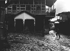
 Since there are remains of the ancient Apamea Kibotus near Dinar , the place was often the destination of research trips. This photo from April 1907 was taken by Gertrude Bell , a traveler to the Orient and shows a fountain in the center of Dinar. |
||||
| Basic data | ||||
|---|---|---|---|---|
| Province (il) : | Afyonkarahisar | |||
| Coordinates : | 38 ° 4 ' N , 30 ° 10' E | |||
| Height : | 880 m | |||
| Residents : | 25,178 (2012) | |||
| Telephone code : | (+90) | |||
| Postal code : | 03400 | |||
| License plate : | 03 | |||
| Structure and administration (as of 2013) | ||||
| Mayor : | Saffet Acar ( MHP ) | |||
| Website: | ||||
Dinar (formerly Geyikli ) is a city in the Afyonkarahisar province in southwest Turkey . It is the administrative center of the district of the same name and has 25,178 inhabitants.
In an earthquake on October 1, 1995 with a magnitude of 6.1 on the Richter scale , 94 people were killed and 250 injured. The city was largely destroyed and rebuilt in the following years.
The Kufi, the southern source river of the Great Meander , has its source in Dinar . In ancient times the place was first called Kelainai , later Apameia Kibotos and was known for its mint workshops.
literature
- Gustav Hirschfeld: About Kelainai-Apameia Kibotos . Berlin 1875. (Treatises of the Royal Academy of Sciences in Berlin, 1875)
- Mehmet Özalp: Marsyas'ın İlinden / From the province Marsyas . Denizli 1997.
Web links
Commons : Dinar - collection of pictures, videos and audio files
Individual evidence
- ^ Turkish Institute for Statistics ( Memento from April 18, 2013 in the web archive archive.today ), accessed July 7, 2013

