Dinder (river)
|
Dinder Dindar |
||
|
The Dinder in the catchment area of the Blue Nile (center) |
||
| Data | ||
| location |
|
|
| River system | Nile | |
| Drain over | Blue Nile → Nile → Mediterranean | |
| source | About 100 km west of Lake Tana in the Ethiopian highlands | |
| muzzle | about 200 km south of Khartoum in the Blue Nile Coordinates: 14 ° 6 ′ 10 ″ N , 33 ° 39 ′ 57 ″ E 14 ° 6 ′ 10 ″ N , 33 ° 39 ′ 57 ″ E |
|
| Mouth height |
400 m
|
|
| Catchment area | 32,385 km² | |
| Discharge at the Gwasi A Eo gauge: 32,385 km² at the mouth |
MNQ 1900–2002 MQ 1900–2002 Mq 1900–2002 MHQ 1900–2002 HHQ (max. Month Ø) |
0 l / s 88.6 m³ / s 2.7 l / (s km²) 379 m³ / s 763 m³ / s |
|
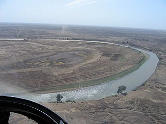
the dinder from an airplane |
||
The Dinder ( Arabic نهر الدندر Nahr-ud-dindir , also Dindar) is a seasonal tributary of the Blue Nile in Ethiopia and Sudan .
course
The river has its source in the Ethiopian highlands about 100 km west of Lake Tana . It flows in a westerly direction and forms the border between the regions of Amhara and Benishangul-Gumuz . Shortly before the border with Sudan, it swings to the northwest. In Sudan it flows through the Dinder National Park , which it also gives its name to. The Dinder flows into the Blue Nile in the Nubian Desert , about 200 km before it reaches Khartoum .
Hydrometry
The flow rate of the river was measured for 102 years (1900–2002) at the Gwasi gauge, directly at the mouth, in m³ / s.


