
Benishangul-Gumuz
| Benishangul-Gumuz | ||
|---|---|---|
  |
||
| Symbols | ||
|
||
| Basic data | ||
| Country | Ethiopia | |
| Capital | Asosa | |
| surface | 50,248 km² | |
| Residents | 670,847 (2007) | |
| density | 13 inhabitants per km² | |
| ISO 3166-2 | ET-BE | |
| politics | ||
| Head of government | Ashadli hating | |
| Political party | Benishangul Gumuz People's Democratic Party | |

Coordinates: 10 ° 18 ' N , 35 ° 0' E
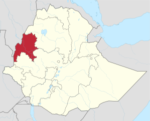
Benishangul-Gumuz (also Benshangul-Gumuz , Beni Schangul-Gumuz ; Amharic ቤንሻንጉል-ጉምዝ Benəšangul Guməz , also ቤንሻንጉል-ጉሙዝ Benəšangul Gumuz ) is one of the nine administrative regions of Ethiopia . It is located in the west of the country, on the border with Sudan and South Sudan . Its capital is Asosa .
The region was formed after 1991 from parts of the former woolga and Goddscham provinces . Beni Schangul or Bela Schangul was the name of a sultanate under the leadership of Berta , which was incorporated into Ethiopia at the end of the 19th century; Gumuz is the name of the second largest indigenous people group.
geography
The Blue Nile (Abbai) crosses the region from east to west.
Administratively, Benishangul-Gumuz is divided into the three zones Metekel , Asosa and Kemashi (Kamashi), which are further subdivided into woredas such as Dangur . According to documents from the Central Statistics Agency of Ethiopia from 2007, there are also the Pawe Special Woreda and the Mao Komo Special Woreda , which are not subject to any zone. A map of the Ethiopian Disaster Prevention and Preparedness Agency , on the other hand, shows a Tongo Special Woreda next to the three zones .
population

The majority of the long-established population belong to the Berta and Gumuz ethnic groups , who speak Nilo-Saharan languages and are socio-culturally closer to the ethnic groups in Sudan than to those in the rest of Ethiopia. In addition, numerous Oromo and - as a result of the resettlement campaigns of the Mengistu regime in the 1980s - Habesha , especially Amharen from Wollo , live in the region. There have often been tensions between these groups.
According to the official census results of 2007, of 670,847 inhabitants, 25.9% (173,743) were Berta, 21.25% (142,557) Amharen, 21.11% (141,645) Gumuz, 13.32% (89,346) Oromo, 7.59% (50,918) Shinasha , 4.24% (28,467) Agau , 1.9% (12,477) Mao and 0.96% (6,464) Komo . 45.4% were Muslims, 33% Ethiopian Orthodox , 13.5% Protestants and 7.1% followers of traditional religions. The annual population growth rate between 1994 and 2007 was the second highest in the country at 3%.
13.5% of the population lived in cities. The largest city is the capital Asosa with over 20,000 inhabitants, other larger towns are Manbuk , Dibate , Bulen and Bambasi .
In 2005, 48.4% of the children in Benishangul-Gumuz (49.7% of the boys, 47.1% of the girls) attended primary school. 15.3% (17.9% boys, 12.6% girls) went to secondary school.
languages
In 1994, of 460,469 inhabitants, 24.8% Berta , 23.12% Gumuz , 22.75% Amharic , 15.86% Oromo , 4.18% Shinasha and 3.56% Agaw. 23.8% of the population spoke a second language: 10.16% also spoke Oromo, 7.38% Amharic.
Amharic is the working language of the region.
history
Like the Gambella region, Benishangul-Gumuz is historically closely connected with the neighboring areas of Sudan , and to a lesser extent with the Ethiopian highlands . These regions served as slave hunting grounds since the Aksumite period, and their Nilo-Saharan-speaking inhabitants were disparagingly called Shanqella (Šanqəlla, also Shanqila, Shankella) by the highland Ethiopians . Along with slaves, gold has traditionally been an important export good from Benishangul.
Little is known about history prior to the 19th century. Archaeologists have found sites dating back to the end of the 1st millennium BC. Or the beginning of the 1st millennium AD and assign them to the forerunners of today's Komuz -speaking ethnic groups. Finds that they attribute to Berta date back to the 17th to 20th centuries and are mainly on mountains, hills and in rocky areas that are easy to defend. It was not until the middle of the 20th century that Berta also settled in the lowlands, as slave hunts and armed conflicts were over.
The area was a "buffer zone" or "no man's land" between the southern Sannar and Damot in the highlands. The Ethiopian Emperor Sissinios (Susenyos) invaded the area in 1617/18, and in 1685 it fell to the Funj .
According to Negasso Gidada , Oromo's advance into the region began in the mid-18th century.
In the first quarter of the 19th century, Arab traders came from Sannar, which was occupied by Ottoman Egypt from 1821 . They mingled with families from the Berta upper class and thus gained political influence. By the middle of the century the waṭāwiṭ , the descendants of Arabs and Berta, had become the new ruling class. They also began to spread Islam to Berta. Various trade routes met in Benishangul, and local gold and Ethiopian amole were exchanged for slaves, cattle, horses, iron, civet , musk , coffee, ivory and honey (which also came from the Oromo areas of Sibu and Leeqaa ). Luxury goods such as textiles and glass beads were imported via Sudan.
In the further course of the 19th century, Benishangul was affected by the Mahdi uprising . At the end of the 19th century, Ethiopia annexed the sultanates of Beni Shangul and Gubba (Arabic Qubba) under Menelik II . In 1898 Asosa became the political and economic capital. Until the Italian occupation of Ethiopia in the mid-1930s, the area supplied gold and slaves to the central government on a large scale. Slaves were also smuggled into Sudan across the border established in 1902.
Under the regime of Mengistu Haile Mariam , who ruled Ethiopia from 1974, around 250,000 highland farmers affected by drought and hunger - mostly Amharen from the Wollo province - were resettled to Benishangul-Gumuz from 1979 and especially in the mid-1980s .
The resistance against the Mengistu regime came here mainly from the Berta. In addition, the Oromo Liberation Front (OLF) fought for the area in the Ethiopian civil war at the end of the 1980s and the beginning of the 1990s - supported by the Eritrean People's Liberation Front , which had meanwhile advanced far south from Eritrea . The OLF tried to involve the local population as “black Oromo”, but met with little support. Instead, the Berta rebels allied with the TPLF , which overthrew the Mengistu regime in 1991 with the EPRDF coalition . As Berta People's Liberation Movement or Benishangul People's Liberation Movement (BPLM) they - like the Gambella People's Liberation Movement of the Anuak in Gambella - were not accepted as full members of the EPRDF, but became regional partners of the new ruling coalition.
politics
The EPRDF, which has ruled Ethiopia since 1991, reformed the administrative structure of Ethiopia and introduced ethnically defined regions or states instead of the provinces (ethnic federalism). This is how today's Benishangul-Gumuz region emerged from parts of the woolga and gojjam provinces .
Within the BPLM, which provided the government of the new region, various factions competed for resources and offices as well as ideologically . One of the three factions was influenced by the Sudanese government of the National Islamic Front (NIF). This tried to gain influence in the partly Muslim border region and promoted Islamist tendencies. The corresponding BPLM parliamentary group called for “national self-determination” for Benishangul-Gumuz, which the EPRDF saw as striving for a connection to Sudan. In addition, there were conflicts between the Berta and other ethnic groups like the Gumuz, who felt politically disadvantaged.
From 1995 the EPRDF took action against the influence of the Sudanese government in Benishangul-Gumuz. For this purpose, it also allowed the South Sudanese rebel army SPLA to establish bases in the region. In 1996 she organized a "Conference for Peace and Democracy" and founded the Benishangul Gumuz People's Democratic Unity Front (BGPDUF) as a new allied party.
In the parliamentary elections in Ethiopia in 2005 , eight of the region's nine seats went to the BGPDUF and one to the opposition CUD / Qinijit . The Regional State Council, also elected in 2005, is composed as follows:
| Party or alliance | Seats (99) | proportion of |
|---|---|---|
| BGPDUF | 85 | 85.9% |
| Qinijit Coalition | 11 | 11.1% |
| Ethiopian Berta People's Democratic Organization | 1 | 1 % |
| Independent | 2 | 2% |
literature
- Alessandro Triulzi: Salt, Gold, and Legitimacy: Prelude to the History of a No-Man's Land, Belā Shangul, Wallaggā, Ethiopia (ca.1800-1898) , 1981
- John Young: Along Ethiopia's Western Frontier: Gambella and Benishangul in Transition , in: The Journal of Modern African Studies , Vol. 37/2, June 1999 (pp. 321–346)
- Abdussamad H. Ahmad: Trading in Slaves in Bela-Shangul and Gumuz, Ethiopia: Border Enclaves in History, 1897–1938 , in: Journal of African History , 40, 1999 (pp. 433–446)
- Richard Pankhurst: The history of the Bareya, Shanqella and other Ethiopian slaves from the borderlands of the Sudan. In: Sudan Notes and Records. 58, 1977, ISSN 0375-2984 , pp. 1-43.
Web links
- Map of the region at the Ethiopian Disaster Prevention and Preparedness Agency with different subdivisions (PDF; 269 kB)
- Alfredo González-Ruibal, Víctor M. Fernández Martínez: Exhibiting Cultures of Contact: A Museum for Benishangul-Gumuz, Ethiopia (PDF; 456 kB), in: Stanford Journal of Archeology 5, 2007, pp. 61-90
Individual evidence
- ↑ a b c Central Statistics Agency (CSA): 2005 National Statistics, Section – B Population ( Memento from February 4, 2016 in the Internet Archive ) (PDF; 1.8 MB)
- ↑ a b Abdulkader Saleh, Nicole Hirt, Wolbert GC Smidt, Rainer Tetzlaff (eds.): Peace spaces in Eritrea and Tigray under pressure: Identity construction, social cohesion and political stability , LIT Verlag, Münster 2008, ISBN 978-3-8258-1858 -6 (p. 348)
- ^ A b c d e f John Young: Along Ethiopia's Western Frontier: Gambella and Benishangul in Transition , in: The Journal of Modern African Studies , Vol. 37/2, June 1999
- ↑ a b c CSA: Summary and Statistical Report of the 2007 Population and Housing Census Results ( Memento of March 5, 2009 in the Internet Archive ) (PDF; 4.7 MB), (pp. 11, 19, 74-75, 96 -98, 111-112)
- ↑ a b CSA: The 1994 Population and Housing Census of Ethiopia: Results for Benishangul-Gumuz Region, Volume I: Statistical Report , 1996 (PDF; 48.4 MB), pp. 47, 54
- ↑ Disaster Prevention and Preparedness Agency: Administrative Region and Woreda Map of Benishangul and Gumuz ( Memento of September 27, 2007 in the Internet Archive ), 2006 (PDF; 269 kB)
- ↑ CSA: Ethiopia Demographic and Health Survey, 2005, p. 20
- ^ Basic information from the Ethiopian Parliament on Benishangul-Gumuz ( Memento from September 26, 2010 in the Internet Archive ). Retrieved May 15, 2010.
- ↑ a b c d e Alessandro Triulzi: Beni Šangul , in: Siegbert Uhlig (Ed.): Encyclopaedia Aethiopica , Volume 1, 2003, ISBN 3-447-04746-1
- ↑ a b Alessandro Triulzi: Trade, Islam, and the Mahdia in Northwestern Wallaggā, Ethiopia , in: The Journal of African History , Vol. 16/1, 1975, pp. 55-71
- ↑ Alfredo González-Ruibal , Víctor M. Fernández Martínez: Exhibiting Cultures of Contact: A Museum for Benishangul-Gumuz, Ethiopia (PDF; 456 kB), in: Stanford Journal of Archeology 5, 2007, pp. 61-90
- ↑ Negasso Gidada: History of the Sayyoo Oromoo of Southwestern Wallaga, Ethiopia from about 1730 to 1886 , Addis Abeba 2001 (quoted in González-Ruibal and Fernández Martínez)
- ↑ Alessandro Triulzi: Asosa , in: Siegbert Uhlig (Ed.): Encyclopaedia Aethiopica , Volume 1, 2003, ISBN 3-447-04746-1
- ↑ Alex de Waal, Africa Watch: Evil Days. 30 Years of War and Famine in Ethiopia , 1991, ISBN 978-1-56432-038-4 (pp. 317f., 322-324, 326, 328)
- ↑ a b Paulos Chanie: Clientelism and Ethiopia's post-1991 decentralization , in: Journal of Modern African Studies 45/3, 2007
- ↑ Official election results for the House of Peoples' Representatives ( Memento of July 6, 2007 in the Internet Archive ) (PDF), electionsethiopia.org.
- ^ African Elections Database : Results of the elections in Benishangul-Gumuz , accessed on June 15, 2010
Afar |
Amhara |
Benishangul-Gumuz |
Gambela |
Harar |
Oromia |
Somali |
Region of Southern Nations, Nationalities, and Peoples |
Tigray
and the cities of Addis Ababa and Dire Dawa