
Lake Tana
|
Lake Tana ጣና ሐይቅ |
||
|---|---|---|

|
||
| Lake Tana seen from space, 1991 | ||
| Geographical location | Abyssinia highlands in Ethiopia ( East Africa ) | |
| Tributaries | Gilgel Abay (Little Abbai), Gumara and Rib | |
| Drain | Blue Nile | |
| Places on the shore | Bahir Dar | |
| Data | ||
| Coordinates | 12 ° 1 ′ N , 37 ° 18 ′ E | |
|
||
| Altitude above sea level | 1786 m | |
| surface | about 3000 km² | |
| length | 70 km | |
| width | 65 km | |
| volume | about 24 km³ | |
| Maximum depth | 14 m | |
| Middle deep | 8 m | |
|
particularities |
highest lake in Africa, largest Ethiopia |
|

|
||
| Map by James Bruce (1790) | ||

The Lake Tana ( Amharic ጣና ሐይቅ t'ana häyq ), also Tsanasee or Dembeasee called, is located in the highlands of Abyssinia in Ethiopia ( East Africa ). It is Africa's highest and Ethiopia's largest lake. Since 2015, Lake Tana has been part of a biosphere reserve : the Lake Tana Biosphere Reserve.
geography
Location and size of the lake
It is located in the middle of a hilly landscape in a large basin- shaped basin around 370 km northwest of Addis Ababa and around 70 km south of Gonder at an altitude of around 1786 m above sea level. It is approx. 70 km long and up to 65 km wide and has an area of more than 3000 km². Its depth is on average 8 m, maximum only about 14 m. The lake level originally fluctuated by around 1.6 m depending on the amount of precipitation, with the peak being reached in August with a precipitation of 500 mm (per month). As a result, larger areas of shore land were flooded, which contributed to the fertility of the fields.
At the southern tip of the lake is Bahir Dar , the capital of the Amhara Province and the third largest city in Ethiopia. There are numerous islands in the lake, the number of which varies depending on the water level. The latest counts assume around 30 islands.
Catchment area, tributaries
Lake Tana has a catchment area of 15,054 km². according to other data of 15,340 km². Annual rainfall is between 1450 mm in Bahir Dar and 1050 mm in Gondar. The rainy season in the south of the catchment area lasts from April / May to October / November, in the northern areas it is a little shorter.
The lake has more than 30 tributaries, the largest being the Gilgel Abay (Little Abbai), the Gumara and the Rib . The Kleine Angereb is also worth mentioning , where the Angereb Reservoir was built to supply the city of Gonder with drinking water .
Drains
The natural outflow of the lake is the Abbai ( English Abay or Abbay ), as the Blue Nile is called in Ethiopia, near Bahir Dar. The discharge has been regulated since 1996 by the 3 m high Chara-Chara weir , with which the water level of the lake is between 1784 m and (including an overflow of 0.5 m) a maximum of 1787.5 m above sea level. d. M. can be regulated.
The Chara Chara weir was built to compensate for the strong fluctuations in the height of the water level due to the rainy seasons and to ensure sufficient water for the Tis Abay power plants , which are about 30 km downstream, even in the dry season.
Since the Tana Beles power plant went into operation in 2010, Lake Tana has had another outflow through this power plant into the Beles , which flows into the Blue Nile just before the Sudanese border.
use
The catchment area of Lake Tana consists of barely (still) forested mountainous land, which is cultivated by the increasing population up to ever greater heights for their own use on usually less than half a hectare per family. About 3 million people live in the area, most of whom live in extremely modest conditions on agriculture and fishing.
According to the Ethiopian Department of Fisheries and Aquaculture, a total of 1,454 tons of fish were landed in Bahir Dar in 2002; this is only 15% of the sustainably available amount. Others point out how easily fish stocks can be endangered.
Tourism to the monasteries and the waterfalls is playing an increasing economic role.
12 ships of the state-owned Lake Tana Transport Enterprise operate on the lake , which transport people and cargo (as of 2008). Four of the ships still date from the time of Italian East Africa , which were sunk by the withdrawing Italians in 1941 and then lifted and repaired by Ethiopian initiative. For 40 years they were the company's only boats.
In addition, the traditional tankwas , boats of various sizes made from papyrus , ranging from one-man canoes to barges, are used.
particularities
Lake Tana is an important regulator for the dry season, it contributes 25% of the water of the Abbay on the Sudanese border during the dry season. However, because of its shallow depth, it is susceptible to events that would otherwise not have comparable effects. During the drought in 2003, the lake's water level fell by 2 m, partly due to the needs of the Tis Abay power plants . As a result, its surface area was reduced by 35 km² and shipping had to be suspended for three months. During the 2006 flood, however, more than 15,000 hectares were inundated, 10,000 people were displaced and 2,500 domestic animals were washed away. The increasing erosion accelerates the silting up of the lake.
Now that the Tana Beles power station has created additional drainage water requirements, the future of Lake Tana and its inhabitants will depend to a large extent on the correct control of the Chara-Chara weir.
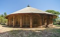
Monasteries
On 20 of the 30 islands of Lake Tana there are monasteries, some of which were founded in the 14th century. They are located on the islands of Birgida Maryam , Daga (name of the monastery: Dega Estefanos ), Dek , Narga , Tana Cherkos , Mitsele Fasilidas , Kebran and Debre Maryam . Churches and monasteries have also been built on the Gorgora , Mandaba and Zeghe peninsulas .
gallery
Church in the Kebran St. Gabriel Monastery

Church frescoes in the Aba Entons monastery

View over Lake Tana near Gorgora
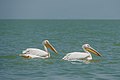
Pelicans on Lake Tana

Fishermen on Lake Tana

Hippos in the water near the Blue Nile outflow

A tankwa made from papyrus


Web links
- Lake Tana project page of the Naturschutzbund (NABU) eV
- Pictures of Lake Tana and the monasteries
- Map (northern part)
- Map (southern part)
- Newspaper article about the Tanasee dam project (1920 / 1930s) in the 20th century press kit of the ZBW - Leibniz Information Center for Economics .
Notes and individual references
- ↑ Homepage of the Lake Tana Biosphere Reserve. Retrieved September 27, 2017 .
- ↑ In Ethiopian springs today the regulated water level is between 1784 and 1787 m above sea level. d. M. stated. Earlier heights fluctuated: Ein Weltatlas, Gondrom, 1994 and Eshete Dejen [1] : 1,830 m; Brockhaus and English special stage: 1,840 m above sea level M.
- ↑ In Meyer's Konversations-Lexikon depths over 100 meters are given.
- ↑ a b Eshete Dejen: Lake Tana and its environment: Threats for sustainable management
- ↑ According to Brockhaus from 1934, 600 km² are flooded in the rainy season, which is probably the reason for the very different surface information: Eshete Dejen: 3,050 km²; English WP: 3,000–3,500 km², www.tiscali: 3,600 km², www.encyclopedia2: 3,620 km².
- ↑ The catchment area of Lake Tana is part of the catchment area of the Blue Nile, which covers around 200,000 km² in Ethiopia.
- ^ Tana & Beles Integrated Water Resources Development Project, World Bank Project Appraisal Document No: 43400-ET
- ↑ Melkamu Amare Aragie: Reservoir Operation and Establishment of Operation Rules for Lake Tana ( page no longer available , search in web archives ) Info: The link was automatically marked as defective. Please check the link according to the instructions and then remove this notice. Dissertation from January 2005 at Addis Ababa University, School of Graduate Studies, Faculty of Technology, Department of Civil Engineering, p. 1
- ↑ Melkamu Amare, dissertation, p. 10
- ^ A b Tana & Beles Integrated Water Resources Development Project, World Bank Project Appraisal Document No: 43400-ET, p. 1
- ↑ The World Bank states an average annual income of US $ 125 (Report 43400 from May 2, 2008)
- ^ Information on Fisheries Management in the Federal Democratic Rupublic of Ethiopia
- ↑ Ethiopia: Lake Tana Transport Reels in US $ 18.1 million for New Boats on allAfrica.com