Dirnismaning
|
Dirnismaning
Garching municipality near Munich
Coordinates: 48 ° 13 ′ 47 " N , 11 ° 38 ′ 28" E
|
|
|---|---|
| Height : | 486 m |
| Residents : | 150 |
| Postal code : | 85748 |
| Area code : | 089 |
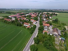
Dirnismaning is a district of the city of Garching near Munich in the district of Munich ( Bavaria ). The place has about 150 inhabitants.
Dirnismaning borders on Garching near Munich, Ismaning , Hochbrück (city of Garching) and the state capital of Bavaria Munich . The border to Ismaning is formed by the left bank of the Isar. Here the Kollmannssteg crosses the Isar at river kilometer 136 .
The Schleissheim Canal runs between Ort and Isar and bends west to the north of the village in the direction of Schleissheim . Garching harbor was at the kink .
Web links
Commons : Dirnismaning - collection of images, videos and audio files
