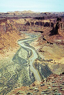
Dirty Devil River
| Dirty Devil River | ||
|
Dirty Devil River near the Twin Corral Box Canyon |
||
| Data | ||
| Water code | US : 1427408 | |
| location | Utah (USA) | |
| River system | Colorado River | |
| Drain over | Colorado River → Gulf of California | |
| origin | The confluence of the Fremont River and Muddy Creek near Hanksville 38 ° 24 ′ 9 ″ N , 110 ° 41 ′ 35 ″ W |
|
| muzzle | in Garfield County in the Colorado River Coordinates: 37 ° 53 ′ 30 " N , 110 ° 23 ′ 33" W 37 ° 53 ′ 30 " N , 110 ° 23 ′ 33" W |
|
| Mouth height |
1129 m
|
|
| length | 129 km | |
| Catchment area | 1945 km² | |
The Dirty Devil River is a right tributary of the Colorado River with a length of approximately 129 km in central southern Utah . It is created in Wayne County near Hanksville by the confluence of the Fremont River and Muddy Creek . The Dirty Devil River flows through 600 m deep canyon in Garfield and Wayne Counties. On its last 20 miles it flows through the Glen Canyon National Recreation Area before flowing into the Colorado River. It drains an area of 1945 km².
