
Dolmen from the Coll de la Farella
| Dolmen from the Coll de la Farella | |||
|---|---|---|---|
 Dolmen from the Coll de la Farella |
|||
|
|||
| Coordinates | 42 ° 26 '6 " N , 3 ° 7' 42.5" E | ||
| place | Portbou , Catalonia , Spain | ||
| height | 380 m | ||

The dolmen of the Coll de la Farella is a small dolmen in the municipality of Portbou in northern Catalonia ( province of Girona , Alt Empordà ).
location
The dolmen stands on a ridge on the northern edge of the municipality of Portbou at 380 meters above sea level. It is about halfway between the eponymous Coll de la Farella (306 meters) 500 meters further east and the Puig de l'Álisa (527 meters) in the west. The municipal boundary to Cerbère and also the French-Spanish state border runs over the ridge . The ridge begins at Puig Cervera (205 meters), which is located directly on the Mediterranean, and then rises above the Coll dels Belitres (165 meters).
description
The dolmen of the Coll de la Farella is in poor condition, but can possibly be assigned to a gallery tomb with a trapezoidal chamber, like so many other dolmens in the Albères massif . Only the orthostats have survived (six, partly quite small side stones and a larger end stone). The cover plate is missing. The side stones have assumed a clear incline due to the slope. The ridge path passes right next to it.
For the construction of the dolmen blocks of the shale rock were used, which are relatively weakly metamorphosed and come from the Paleozoic . The rocks form part of the metasediment cover of the Albères massif, which belongs to the Pyrenees .
- Coll de la Farella

View of the dolmen, looking west towards the Puig de Querroig

Large side orthostat on the valley side

Looking south-east to Portbou
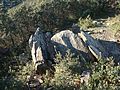
View from the east, clearly recognizable the inclined position of the orthostats

inside view


Individual evidence
- ↑ Carreras Vigorós, Enric and Tarrus Galter, Josep: 181 anys de recerca megalítica a la Catalunya Nord (1832-2012) . In: Annals de l'Institut d'Estudis Gironins, 54 . Girona: Institut d'Estudis Gironins 2013, p. 31-184 .