
Coll dels Belitres
| Coll dels Belitres | |||
|---|---|---|---|
 The state border between France and Spain, view towards Portbou |
|||
| Pass height | 165 m | ||
| Department | Pyrénées-Orientales , France | ||
| Valley locations | Cerbère | Portbou | |
| Mountains | Pyrenees | ||
| Map (Pyrénées-Orientales) | |||
|
|||
| Coordinates | 42 ° 26 '6 " N , 3 ° 9' 35" E | ||

The Coll dels Belitres is a 164.6 meter high mountain pass in the eastern Pyrenees that connects northern Catalonia with French Roussillon . The state border between Spain and France runs over it .
Toponymy
The Catalan word coll , French col , means passport. Belitre , French bélître , stands for beggar or crook in Catalan. The Coll dels Belitres - the beggars' pass - was thus a pass through which the smugglers and thieves, frequent in this mountainous border region, escaped.
Geographical location
The Coll dels Belitres, French Col des Balistres , is located in the Serra de l'Albera , between the municipalities of Portbou in the Alt Empordà of the Catalan province of Girona and Cerbère in the French Roussillon ( Pyrénées-Orientales department ). From Cerbère it is 3.5 kilometers on the RN 114 or the current D 914 to the top of the pass, from Portbou 2.5 kilometers on the N-260 (Spain). The top of the pass is on a ridge that comes up from the Mediterranean coast 1000 meters away ( Punta de l'Ocell ). It forms a depression between the 262 meter high Puig dels Frares just 500 meters further west and a 203 meter high elevation 250 meters further east.
The GR 92 long-distance hiking trail also leads past the top of the pass . The ridge below the top of the pass is crossed by the railway tunnel ( Túnel dels Belitres ) built in 1876 on the Perpignan - Girona line. At the top of the pass, the customs buildings still stand on the road, such as the former Spanish customs house built from clunky natural stone and the now abandoned border station on the French side. Also worth mentioning on the pass are the border marker N ° 600 (the penultimate of the Spanish-French Pyrenees border), a water reservoir, a monolith of the Franco regime and a casemate equipped with a gun turret .
geology
Relatively low-metamorphic shale rocks that belong to the green - slate- faced chlorite zone are exposed at the Coll dels Belitres . They are part of the Paleozoic metasediments of the Albères massif and are older than 470 million years BP .
history

After Franco's victory in the Spanish Civil War in 1939, the Coll dels Belitres was one of the main key points through which the exodus of the Republicans ( Retirada ) to France took place. Almost 100,000 of the 470,000 to 480,000 persecuted by the Franco regime fled over the pass to France and from there, in some cases, to Latin America .
memorial
A memorial now commemorates the former Retirada. There are display boards with photographs that the painter Manuel Moros took in February 1939.
Photo gallery

View from the Coll to the northeast to Cerbère

Border cross N ° 600

Display boards of the memorial

Monolith of the Franco regime

Former Spanish customs building
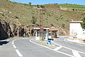
Abandoned customs houses on the Coll
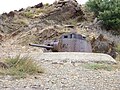
Casemate on the Coll

Reservoir on the Coll

Driveway to the Coll from the Spanish side


See also
Individual evidence
- ↑ Lluís Basseda: Toponymie historique de Catalunya Nord . In: Revista Terra Nostra . t. 1. Prades 1990, p. 796 .