
Puig Cervera
| Puig Cervera | ||
|---|---|---|
 Eastern escarpment of the Puig Cervera over the Mediterranean |
||
| height | 205 m | |
| location |
Pyrénées-Orientales , France Girona Province , Catalonia |
|
| Mountains | Pyrenees | |
| Coordinates | 42 ° 26 '7 " N , 3 ° 10' 15" E | |
|
||
| rock | slate | |
| Age of the rock | Cambrian / Ordovician | |
| particularities | Coast demolition | |

The Puig Cervera is a 205.7 meter high mountain on the border of the southern French municipality of Cerbère and the northern Catalan municipality of Portbou .
Location description
The Puig Cervera is located directly on the Mediterranean coast of the Côte Vermeille and rises directly above the Punta l'Ocell . The distance to the northwestern train station of Cerbère is around 1000 meters (as the crow flies). The French-Spanish state border runs over the Puig Cervera and is marked with the border cross N ° 601 immediately behind the summit. The border then follows the summit ridge further west towards a 178 meter high first saddle. On this ridge there is a transmission mast about 100 meters from the summit.
To the east, the Puig Cervera breaks off steeply to the sea. The surrounding rock is therefore excellently exposed. A cave has formed at the foot of the wall , the Cova Foradada . The beach at the base of the wall is French as Plage du minerai or Catalan as Platja del mineral called.
geology
The geological subsurface of the Puig Cervera is made up of Paleozoic schists from the Albères massif . The rocks metamorphosed towards the end of the Variscan orogeny in the Upper Carboniferous around 300 million years BP are older than 470 million years BP and belong to the chlorite zone of the green schist facies .
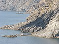
The Punta l'Ocell, the beginning of the state border
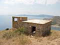
Former sentry

Cova Foradada
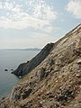
Wall base with Punta l'Ocell

Transmitter mast near the summit

Border cross N ° 601


