
Domaine de Maizerets

The Domaine de Maizerets is a landscaped garden in the Canadian city of Quebec . It is 27 hectares and is located about two and a half kilometers north of the old town in the La Cité-Limoilou arrondissement . The garden, tended by the Société du domaine de Maizerets , is located around the Maison Maizerets (also called Château Ango), a listed manor house from the early 18th century.
history
François Trefflé and Thomas Doyon bought the previously undeveloped area from the Jesuits in 1696 and built a farm the following year. This passed into the possession of the Séminaire de Québec in 1705 . In 1713 a manor house was built, which was responsible for the food supply of the seminar. Troops of the American Continental Army occupied the house in 1775 and set up an artillery battery. When they broke off the siege unsuccessfully in the spring of 1776, they set the building on fire. Based on the foundation walls that had been preserved, the building was rebuilt the following year, with two floors instead of the previous one. From the late 18th century onwards, it was used by priests and schoolchildren to relax in the summer months. It was extended in style in 1826 and 1848/49.
The domain , which was previously called La Canardière (duck pond) , was renamed Maizerets in 1850 , named after the superior Louis Ango de Maizerets (1636–1721), who had once acquired the property for the seminary. In the second half of the 19th and at the beginning of the 20th century, the seminar sold numerous parcels, so that the size of the domain gradually shrank. Residential districts, docks and industrial areas gradually emerged on the sold plots. In 1932 the seminar gave up agricultural use and converted the domain into a holiday complex for young people. In 1973 the main building was placed under protection as a cultural asset and declared a historical monument the following year. In 1979, the domain became the property of the City of Québec and has been open to the public ever since.
description
The Domaine de Maizerets is bounded in the east by the Autoroute 440 and part of the port facilities, in the west by the railway line towards La Malbaie . The southern third includes the area around the historic Château Ango estate . This building is used for exhibitions and events of all kinds. There are also several outbuildings such as a stone barn from 1755 or the Chalet Lacroix built in 1946 , in which the park administration is located, as well as a small chapel . In 1849 a ring-shaped pond was created that surrounds the 18-meter-long Île Saint-Hyacinthe . A small oratory has stood on this artificial island since 1867 .
The middle third is predominantly forested. Landscape design elements can be found predominantly in the northern third. These included a poplar grove , a water garden, a rosarium , a hedge maze with a 350 m long network of paths and an arboretum with 1500 trees representing 215 different species. An observation tower provides an overview . There is an eleven kilometer network of cycling and hiking trails throughout the park; these can be used for cross-country skiing and snowshoeing during the winter season .
photos
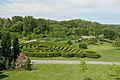
Hedge maze

Observation tower

Pond
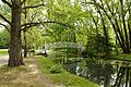
Bridge to the Île Saint-Hyacinthe

Former stable building with barn

Butterfly aviary


Web links
Individual evidence
- ↑ a b Une site marqué par l'histoire. (No longer available online.) Société du Domaine de Maizerets, 2011, archived from the original on November 11, 2014 ; Retrieved November 11, 2014 (French). Info: The archive link was inserted automatically and has not yet been checked. Please check the original and archive link according to the instructions and then remove this notice.
- ^ Maison Maizerets. Répertoire de patrimoine culturel du Québec, 2013, accessed on November 11, 2014 (French).
- ↑ a b Attraits au Domaine de Maizerets. Société du Domaine de Maizerets, 2011, accessed on November 11, 2014 (French).
Coordinates: 46 ° 50 ′ 16.8 ″ N , 71 ° 12 ′ 43.2 ″ W.