Domberg (Suhl)
| Toompea | ||
|---|---|---|
| height | 674.8 m above sea level NHN | |
| location | Thuringia ( Germany ) | |
| Mountains | Thuringian Forest | |
| Coordinates | 50 ° 37 '1 " N , 10 ° 41' 8" E | |
|
|
||
| particularities | - Ottilienkapelle - Bismarck Tower ( AT ) - transmitter mast |
|
The Domberg is 674.8 m above sea level. NHN high mountain in the urban area of Suhl in Thuringia .
The mountain, which is wooded up to the edge of the valley, juts up to the city center on the east side and is Suhl's local mountain , the rocks protruding from the forest there are called Ottilienstein. Numerous allotment gardens and row house settlements were built on the Domberg.
Ottilien Chapel
The small chapel “uff Sanct Ottilien”, built near the Ottilienstein, is said to have once served the miners as a place of worship. In 1528 a miners' festival was celebrated. Local researchers from Suhl have shown, however, that the Annenkapelle, once located on the outskirts of the city, was linked to this mining tradition. According to local tradition, the "Saint Burkhardt" had his quarters in the Ottilienfelsen as a hermit monk. In the 8th century, as an early messenger of Christianity, he fought against the last pagan evidence (spring, rock and tree cults) in the Suhl basin. The Ottilienkapelle is therefore supposed to indicate a formerly pagan site. In the 18th century, a doctor from Suhl accidentally found a mineral spring rising from the rock, which is now known as the "Ottilien spring" and which could be used for healing purposes. When the Reformation was introduced in Suhl in 1544, religious zealots wanted to tear down the already dilapidated Ottilien chapel, but the miners refused to give their consent, as they traditionally asked for heavenly support for their dangerous work underground, the chapel remained. Today's Ottilienkapelle was rebuilt in 1843 and caught fire on April 3, 1945 when the Americans marched into Suhl from shell fire. The parish of Suhl succeeded in rebuilding the Suhl landmark as early as 1953 with donations.
Summit area
Bismarck Tower
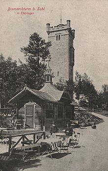
There is a Bismarck tower on the summit of the Domberg . This 21 m high observation tower was built in 1895/1896 from porphyry and limestone by the Suhl master mason Richard Hopf according to the design of the district building inspector Richard Bartels . The city's citizens raised around 14,000 marks for the construction of the tower.
After severe damage as a result of the Second World War, the Bismarck Tower has now been rebuilt as the "Dombergturm". After extensive renovation in 1993 and 1994, the tower was given its original name back in September 1995 and is open to the public all year round. After the surrounding trees were removed in 2001/2002, there is a very good all-round view. Every year at the end of August / beginning of September the "Bismarck Tower Festival" takes place.
Mining lodge
Not far east of the Bismarck Tower is the Dombergbaude, a mountain restaurant with beer garden.
Transmission mast
Approx. 50 m north-west of the Bismarck tower is a transmission mast with an associated company building.
Web links
Individual evidence
- ↑ Map services of the Federal Agency for Nature Conservation ( information )
- ↑ Official topographic maps of Thuringia 1: 10,000. LK Schmalkalden-Meiningen, LK Hildburghausen, LK Sonneberg, district-free city of Suhl . In: Thuringian Land Survey Office (Hrsg.): CD-ROM series Top10 . CD 6. Erfurt 1999.
- ↑ a b Herbert Bauer: Suhl . City and country in the Thuringian Forest. Ed .: Council of the district of Suhl. Progress printer, Erfurt 1955, p. 146-148 .
- ↑ Bismarck Tower Suhl on bismarcktuerme.de
- ↑ Dombergbaude Suhl on the website of Dombergbaude Suhl


