Domnista
|
Domnista municipality Δημοτική Ενότητα Δομνίστας (Δομνίστα) |
||
|---|---|---|
|
|
||
| Basic data | ||
| State : |
|
|
| Region : |
Central Greece
|
|
| Regional District : | Evrytania | |
| Municipality : | Karpenisi | |
| Geographic coordinates : | 38 ° 46 ′ N , 21 ° 52 ′ E | |
| Height above d. M .: | 929-1100-1220 m Psiana-Krikello-Ambliani |
|
| Area : | 215.755 km² | |
| Residents : | 1,072 (2011) | |
| Population density : | 5 people / km² | |
| Code No .: | 300102 | |
| Structure: | 7 local communities | |
| Website: | www.domnista.gr | |
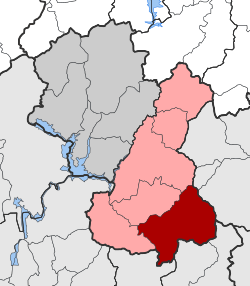
| Located in the Karpenisi municipality and Evrytania regional unit | ||
Domnista ( Greek Δομνίστα ( f. Sg. )) Is a municipality in the municipality of Karpenisi in central Greece .
location
The southeastern municipality of Evrytania borders with Aetolia-Acarnania in the southwest and south and in the east with Fthiotida . These are mainly in the valley of the Krikellopotamos, which stretches from east-northeast to west-southwest through the southern part of the Agrafa Mountains . The Krikellopotamos also flows through the small village of Krikello, the former town hall. The municipality of Dominsta therefore has a strong village and mountainous character; the population density is correspondingly low.
Administrative division
Initially founded as the municipality of Domnitsa as part of the municipal reform in 1997 from the merger of seven rural municipalities, this was merged with another five municipalities after the administrative reform in 2010 . Since then, Domnitsa has been a municipality of Karpenisis , the former rural municipalities form local communities.
| Local community | Greek name | code | Area (km²) | Residents 2011 | Villages and settlements |
|---|---|---|---|---|---|
| Krikello | Τοπική Κοινότητα Κρικέλλου | 30010201 | 51.711 | 161 | Krikello |
| Ambliani | Τοπική Κοινότητα Άμπλιανης | 30010202 | 37,321 | 13 | Ambliani |
| Domista | Τοπική Κοινότητα Δομνίστης | 30010203 | 32,170 | 334 | Domista, Marinos, Skopia |
| Mesokomi | Τοπική Κοινότητα Μεσοκώμης | 30010204 | 25.743 | 150 | Mesokomi, ryaki |
| Roska | Τοπική Κοινότητα Ροσκάς | 30010205 | 26,832 | 101 | Roska, Stournara |
| Stavli | Τοπική Κοινότητα Στάβλων | 30010206 | 18.279 | 253 | Stavli |
| Psiana | Τοπική Κοινότητα Ψιανών | 30010207 | 23.699 | 60 | Agios Charalambos, Psiana, Vythisma, Kastanoula, Paleochori |
| total | 300102 | 215.755 | 1072 | ||
Individual evidence
- ↑ Results of the 2011 census at the National Statistical Service of Greece (ΕΣΥΕ) ( Memento from June 27, 2015 in the Internet Archive ) (Excel document, 2.6 MB)
- ↑ Law 2539/1997 «Συγκρότηση της Πρωτοβάθμιας Τοπικής Αυτοδιοίκησης.», ΦΕΚ 244A / 4.12.1997, Άρθρο 1. κ. P. 8800. PDF Online (Greek)
- ↑ Law 3852/2010, «Νέα Αρχιτεκτονική της Αυτοδιοίκησης και της Αποκεντρωμένης Διοίκησης - Πρόγραμμα Καλης. ΦΕΚ 87 A / 7.6.2010, Άρθρο 1. Σύσταση δήμων. P. 1788. PDF Online (Greek)

