Doornenburg
 flag |
 coat of arms |
| province |
|
| local community |
|
| surface | 8.37 km 2 |
| Residents | 2,350 (Jun. 30, 2017) |
| Coordinates | 51 ° 53 ' N , 6 ° 0' E |
| Important traffic route |
|
| prefix | 0481 |
| Postcodes | 6686-6687, 6691 |
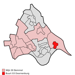
| Location of Doornenburg in the municipality of Lingewaard | |
| Doornenburg Castle | |
Doornenburg is a village in the Dutch municipality of Lingewaard in the province of Gelderland , south of Huissen . Doornenburg has 2,350 inhabitants (as of June 30, 2017).
The village is geographically located at the point where two thirds of the Rhine flows into the Waal and one third into the Pannerdens Canal .
In addition to this strategically favorable location, Doornenburg is best known for its Doornenburg Castle (Dutch: Kasteel Doornenburg ). The Dutch television series Floris was recorded here. The former fortress Fort Pannerden , guarded by former squatters, is another destination.
Associations in Doornenburg
The club life in Doornenburg is very diverse. The largest clubs are:
- Harmony "St. Caecilia Doornenburg "
- Vigilante "Gijsbrecht van Aemstel van Doornenburg en Honderdmorgen"
- Football club "GVA Doornenburg"
- Carnival association "De Riensplitsers"
- Mixed choir "De Burchtsanghers"
- "Lotus Vulgaris" fishing club
- Scouting "St. Maarten Doornenburg "
- Sports club "Olympia"
- "Doornenburg" tennis club
Web links
Commons : Doornenburg - collection of images, videos and audio files
Individual evidence
- ↑ a b Personen met een uitkering; soort uitkering, wijken en buurten 2017 Centraal Bureau voor de Statistiek , accessed on March 24, 2018 (Dutch)

