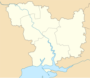
Doroshivka (Voznesensk)
| Doroshivka | ||
| Дорошівка | ||

|
|
|
| Basic data | ||
|---|---|---|
| Oblast : | Mykolaiv Oblast | |
| Rajon : | Voznesensk Raion | |
| Height : | 14 m | |
| Area : | 3.564 km² | |
| Residents : | 2,083 (2001) | |
| Population density : | 584 inhabitants per km² | |
| Postcodes : | 56570 | |
| Area code : | +380 5134 | |
| Geographic location : | 47 ° 29 ′ N , 31 ° 28 ′ E | |
| KOATUU : | 4822082601 | |
| Administrative structure : | 1 village | |
| Address: | вул. Миру буд. 65 56 570 с. Дорошівка |
|
| Website : | Rural community website | |
| Statistical information | ||
|
|
||
Doroshiwka ( Ukrainian Дорошівка ; Russian Дорошовка Doroschowka ) is a village in the Ukrainian Oblast of Mykolaiv with about 2000 inhabitants (2001).
The village was founded as Arnautiwka ( Арнаутівка ) in the second half of the 18th century (another source mentions the year 1795). The first settlers were Moldovans and Ukrainian Cossacks from the Bug Cossack Army. In 1946 the village got its current name.
The village is located on the bank of the Southern Bug , 14 km southeast of the Voznesensk district center and 75 km northwest of the Mykolaiv Oblast center . Doroshiwka has been the administrative center of the rural municipality of the same name in the south of Voznesensk Raion since 2017 , to which the village of Bilousivka with around 1250 inhabitants also belongs. The trunk road N 24 / regional road P-06 runs through the village .
Web links
- Municipal Council website on rada.info (Ukrainian)
Individual evidence
- ↑ a b c local website on the official website of the Verkhovna Rada ; Retrieved September 23, 2018 (Ukrainian).
- ↑ history Doroschiwka in the history of the towns and villages of the Ukrainian SSR ; Retrieved September 23, 2018 (Ukrainian).
- ↑ Subdivision of the rural community on the official website of the rural community; Retrieved September 23, 2018 (Ukrainian).


