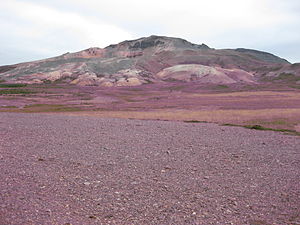
Drápuhlíðarfjall
| Drápuhlíðarfjall | ||
|---|---|---|
|
Drápuhlíðarfjall |
||
| height | 527 m | |
| location | Iceland | |
| Coordinates | 65 ° 1 ′ 0 ″ N , 22 ° 44 ′ 0 ″ W | |
|
|
||
| Type | eroded remnants of a central volcano (extinct) | |
| rock | Rhyolite | |
| Age of the rock | about 3.5 million years | |
| particularities | big landslide | |
The Drápuhlíððarfjall is a 527 meter high volcanic mountain in Iceland .
Surname
The mountain takes its name from the nearby, now abandoned Drápuhlíð farm . drápa is a specific type of poem in Icelandic. It is not known where the name comes from.
location
Drápuhlíðarfjall is located on the north side of the Snæfellsnes peninsula in western Iceland and at the same time near the town of Stykkishólmur . At the same time it is located south of State Road 54 between Álftafjörður (Snæfellsnes) and Stykkishólmur.
geology
Intrusions and eruptions
On the volcanic mountain you can find a lot of rhyolite , among other things in the form of tephra layers , but also intrusions of basalt . This mixture is explained by the proximity to a cooled central volcano many million years old, which is connected to the island of Hrappsey ( Hrappseyjar volcano ). Drápuhlíðarfjall began its own volcanic activity apparently 3.5 million years ago as a basaltic intrusion, but later there were eruptions, this time rhyolite rock.
Fossils
In the higher rock layers of the mountain you can see fossilized remains of trees ( silicified wood ) and other plant remains , as well as holes turned into stone, which left tree trunks burning in lavas.
Whale bones and climate change
In addition, whale bones were found at a considerable height on the mountain, which say something about higher sea levels or lower land.
Landslide
On the northwest side there are clearly recognizable traces of a major landslide . This probably happened shortly after the end of the Ice Age around 10,000 years ago. The rubble tongue that was created is about 1 km long and up to 100 m thick. Two thick layers of rhyolite broke off on the northern part of the mountain .
The uppermost layers consist of thick Liparitlavas, but underneath there is a softer, clay-like layer of pyroclastics , a combination that could lead to further landslides in the future, especially since another crevice has formed on top of the mountain.
Popularity of the rock
As early as the 18th century, the naturalists Eggert Ólafsson and Bjarni Pálsson declared the mountain to be one of the most interesting in the country.
People were particularly fond of the many different types of rock and precious stones such as quartz that existed there. It was also said that gold could be found there.
In the 1960s and 1970s, stones, so-called Drápuhlíðargrjót , were taken from a mine in the north of the mountain in order to cover paths and house walls, because it was given a special aesthetic value. The removal of the stones there (including jasper ) required a permit from the pastor of Stykkishólmur in 1989 and had to pay a fee for this, which the church on Helgafell (Helgafellssveit) benefited from. In the meantime, however, the mountain is under nature protection and it is forbidden to collect stones here, let alone take stone slabs with you to decorate your house or garden.
Hiking up the mountain
You can climb the mountain from the northwest.
See also
Web links
Individual evidence
- ↑ a b c d Ari Trausti Guðmundsson, Pétur Þorleifsson: Íslensk fjöll. Gönguleiðir á 151 tind. Reykjavík (Mál og Menning) 2004, p. 46
- ↑ cf. Kristján Eiríksson, Sigurborg Hilmarsdóttir: Bókastoð. Ágrip af íslenskri bókmenntasögu. Reykjavík (IÐNÚ) 1999, p. 21: " Drápa er kvæði með stefi (...)" (own translation: " Drápa is a poem with rhyme (..)")
- ↑ Haukur Jóhannesson: Yfirlit to Jarðfræði Snæfellsnes. In: Einar H. Kristjánsson: Lýsing Snæfellsness frá Löngufjörum að Ólafsvíkurenni. Ferðafélag Íslands, árbók 1982. Reykjavík 1982, p. 160
- ↑ a b Ari Trausti Guðmundsson, Pétur Þorleifsson: Íslensk fjöll. Gönguleiðir á 151 tind. Reykjavík (Mál og Menning) 2004, p. 47
- ↑ a b Haraldur Sigurðsson: Berghlaup úr Drápuhlíðarfjall í fórtíð og framtíð . December 21, 2009, blog of geologist Haraldur Sigurðsson ; [1] ; Accessed April 24, 2011 (Icelandic)
- ^ Ari Trausti Guðmundsson, Pétur Þorleifsson: Íslensk fjöll. Gönguleiðir á 151 tind. Reykjavík (Mál og Menning) 2004, p. 46f.
- ↑ cf. also Tímalaus hönnun , Morgunblaðið , February 10, 2006 [2] ; Accessed April 24, 2011 (Icelandic)
- ↑ Íslandshandbókin. Náttúra, saga og sérkenni. 1. bindi. Edited by T. Einarsson, H. Magnússon. Reykjavík (Örn og Örlygur) 1989, p. 258

