Draškovec
| Draškovec | ||
|
|
||
| Basic data | ||
|---|---|---|
| State : |
|
|
| County : |
|
|
| Height : | 143 m. i. J. | |
| Residents : | 800 | |
| Telephone code : | (+385) 040 | |
| Postal code : | ||
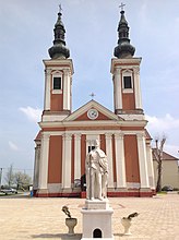
 Church of St. Rochus in Draškovec |
||
Draškovec (ung. Ligetvar ) is a place in Croatia . Draškovec is located near the Drava River and is approx. 5 km from Hungary , 30 km from Slovenia , 75 km from Austria and approx. 100 km from the Croatian capital Zagreb . Nearby towns are Čakovec , Prelog and the town of Ludbreg .
The place has about 800 inhabitants.
history
Draškovec (Hungarian Ligetvar ) is a village in the region and county of Medjimurje in northern Croatia. Before the First World War it belonged to the Imperial and Kingdom of Austria-Hungary. After the First World War it was part of the Kingdom of Serbs, Croats and Slovenes, which was later renamed the Kingdom of Yugoslavia. Draškovec was under Hungarian occupation from 1941 to 1945, then became part of Yugoslavia from 1945 to 1991 and has been part of the Republic of Croatia since 1992.
education
Draškovec has a kindergarten, elementary and secondary school.
Sports
Two clubs operate in the village, u. a.
- Football club NK Draškovec
- Fishing club SRD Smud
Attractions
Draškovec has a church with two bell towers and a park.
Web link
